
The Norfolk Plains - the area around Longford, Cressy, and Perth, south of Launceston - draws tourists to its beautifully preserved historical buildings and pleasant pastoral landscapes, reflecting the fact it was once one of the most important agricultural regions in the whole of Australia. It got its name from the Norfolk Islanders who had been relocated to Tasmania from Norfolk Islandin the early 19th century, to encourage them to take roots in the area. Most failed to see the area's potential and moved on.
Other settlers arrived on the Norfolk Plains and they began buying the properties of the Islanders, or taking up the grants that had been resumed by the Crown as well as new grants of land, often extensive in area. Two of these new settlers were Thomas Archer, and his brother William, who both acquired great wealth based upon pastoralism, and especially wool, unlike the Norfolk Islanders whose resettlement was based upon growing wheat. The estates they established - Woolmers and Brickendon - remain today, both are World Heritage listed.

Tap on image above again to hide this section.


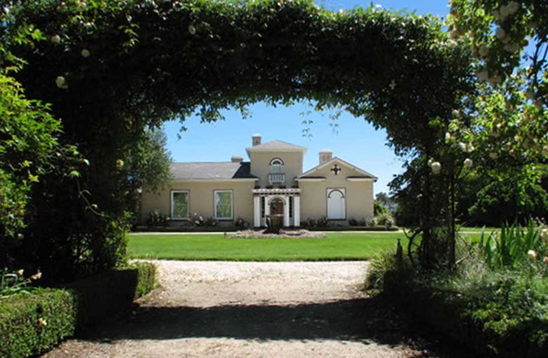
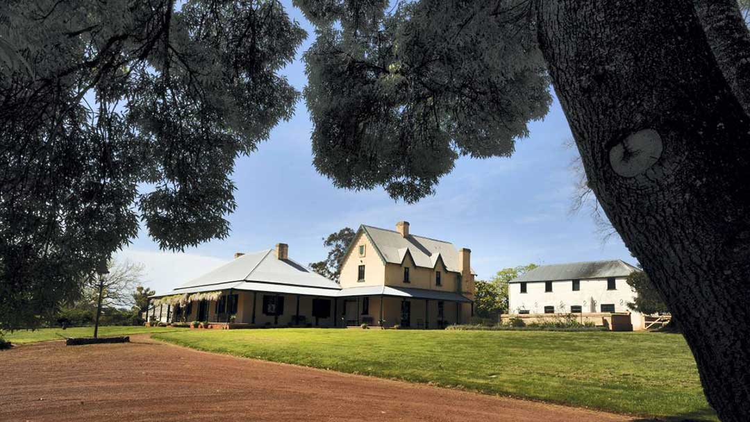
Woolmers Estate, near the village of Longford and overlooking the Macquarie River, is acknowledged as one of the most outstanding examples of 19th century rural settlements in Australia. Accurate and authentic in the minutest detail, it is not difficult to see why the estate has received a World Heritage listing. Location: Woolmers Lane, Longford. Tasmania
More
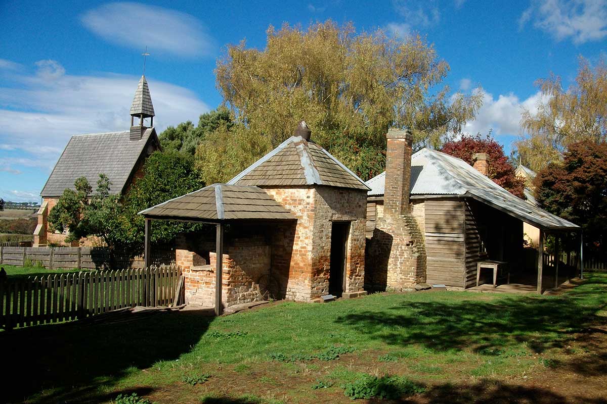
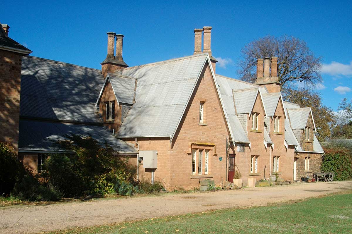
One of Tasmania's World Heritage Convict Sites, Brickendon Historic Farm and Convict Village was built in 1824; the village is still owned by his descendents. The complex affords the a rare chance to see a Georgian homestead, convict-built Gothic chapel, Dutch barns, chicken house, blacksmith shop and tool shed and stay in historic farm cottages. There is also a four hectare (10 acre) historic garden for you to explore.
More
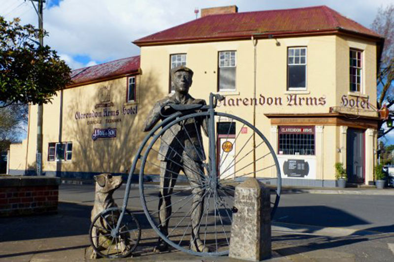
Clarendon House is arguably one of Australia's greatest Georgian houses still standing today. It has formal gardens and grounds, a tree lined avenue, Italianate facade, restored early colonial outbuildings and is owned by the National Trust. The wealthy grazier and merchant James Cox (son of William Cox) had the house built in 1838. An architecturally significant two storey Georgian Regency style mansion which has the only example of a giant order portico on a residence of its period in Australia.
14 km from Launceston (14 mins drive)
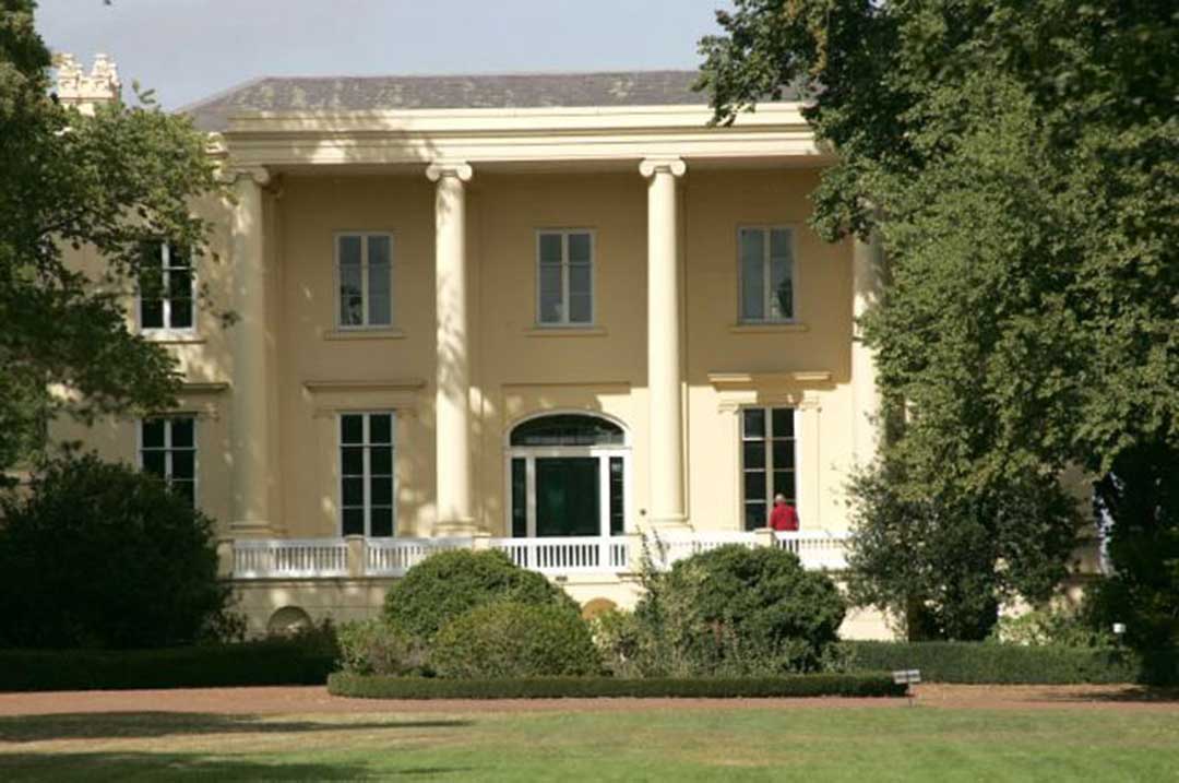
Entally House is a heritage listed property on the western bank of the South Esk river oppoasite the town of Hadspen. Built in 1819 as a wealthy settler's colonial estate, it was the family home of Thomas Reibey, Premier of Tasmania from 1876 to 1877. Entally is set on 85 acres (34 ha) of grounds, and contains a large colonial house, stables, a chapel, other outbuildings and several hectares of vineyards. The buildings are filled with indicative furniture and art of their time, including carriages and coaches in the coach house.
More
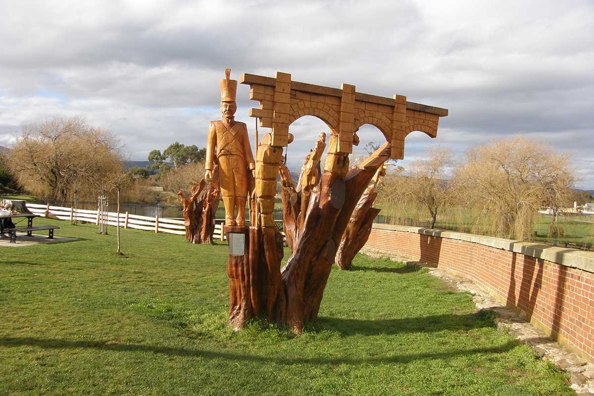
Geeveston Forest & Heritage Centre, which details the history of the timber industry in the area, is located in Geeveston. Outside the Centre is one of many chainsaw-crafted statues of some of the region's memorable personalities dotted around town. A sportsman who has been honoured this way is dual silver-medal winning Olympian, rower Simon Burgess.
More
58 km from Launceston (51 mins drive)
80 km from Devonport (1 hr 13 mins drive)
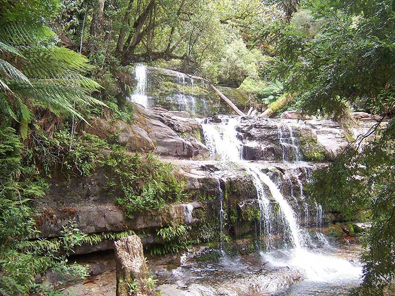
Liffey Falls is a series of four distinct tiered–cascade waterfalls on the Liffey River. The Falls are situated upstream of the town of Liffey, in Meander Valley. The falls commence from the Great Western Tiers at an elevation of 514 metres above sea level and descend in the range of 120–160 metres. Each of the tiered cascades is named in order from upstream to downstream; Alexandra Falls, Hopetoun Falls, The Leap or Spout Falls (also called the Albert Falls), and Victoria Falls.
63 km from Launceston (52 mins drive)
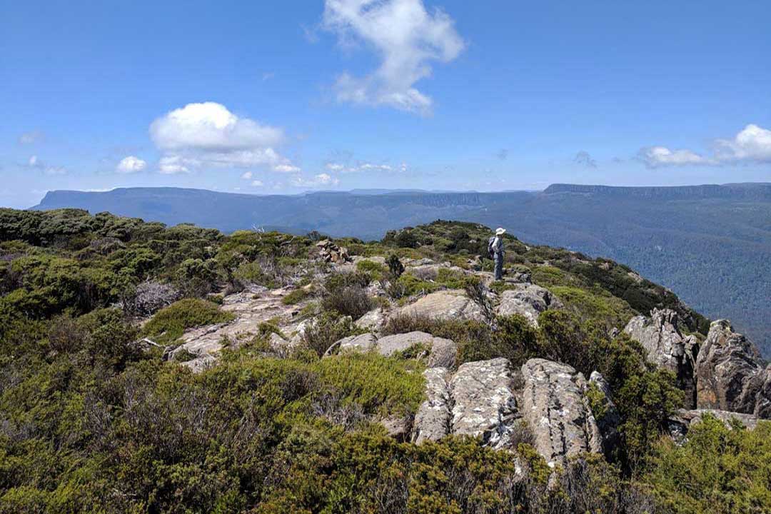
Quamby Bluff is the northernmost peak in the Tasmanian Wilderness World Heritage Area. It provides panoramic views of Northern Tasmania including the Central Plateau and Great Western Tiers. The original inhabitants of the area were the Pallittorre Clan of the northern nation of Aboriginal Tasmanians and lartitickitheker is the Aboriginal name for Quamby Bluff.

Tap on image above again to hide this section.

24 km from Launceston (20 mins drive)
96 km from Devonport (1 hr 3 mins drive)
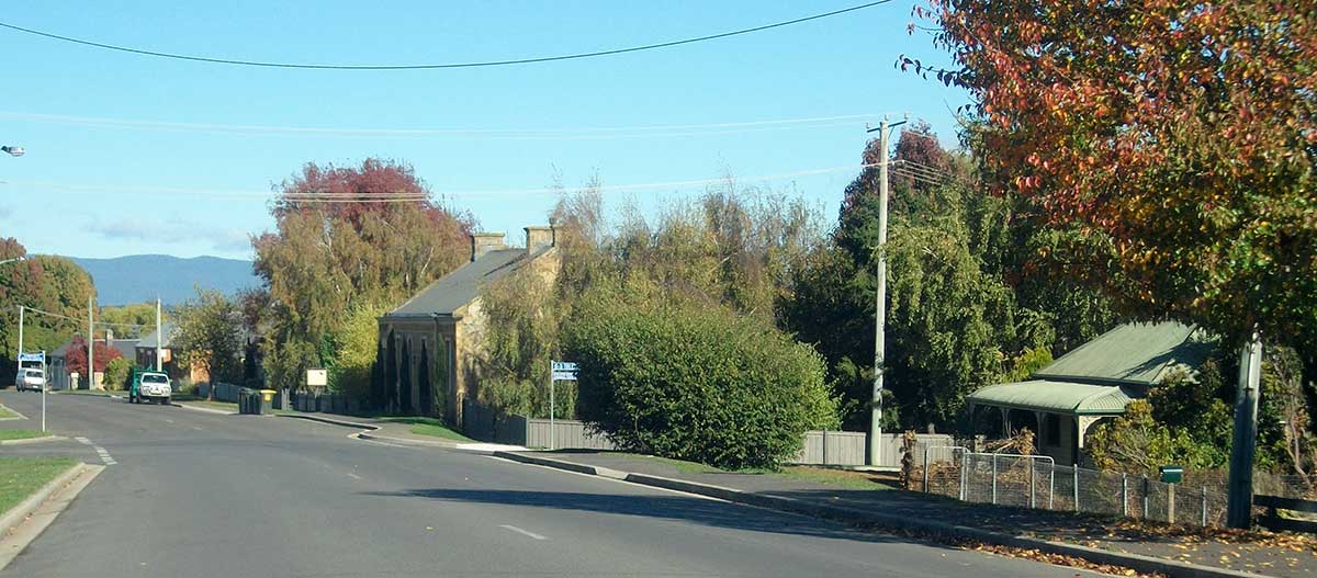
Situated in one of Tasmania's greatest pastoral areas, the town of Longford is an agricultural and administrative centre located at the junction of the South Esk and Macqarie Rivers, in a low-lying highly modified landscape. Longford and its surrounding area is home to some of Tasmania's finest Georgian era buildings and historic farming estates of the Victorian era.
Proceed south out of Longfomd along Wellington Street and you'll pass two historic farming estates, both of which are World Heritage listed convict sites. The first is Brickendon Estate, home to a colonial farm and homestead, fully intact and maintained in its original condition. A visit is highly recommended. Continue along the road and across the river to Woolmers Lane and you will come to another World Heritage listed farming complex - Woolmers. Guided tours through the homestead, farm buildings and rose garden are a highlight of a visit.
More
20 km from Launceston (19 mins drive)
A classified historic town, Evandale is a storehouse of superb Georgian heritage buildings which remain in largely original condition. It is an agricultural and administrative centre located on a knoll rising from highly modified plains. Just minutes down the road from Launceston Airport, Evandale offers accommodation with that lovely village atmosphere.
More

18 km from Launceston (16 mins drive)
A National Trust classified town situated by the South Esk River, Perth is the first major town out of Launceston on the route to Hobart, and also serves as a major junction for people bypassing Launceston on the route from Hobart to the northwest of the state. Perth is a quiet historic village which has largely been by-passed by the tourism that has turned many of Tasmania's other historic villages into centres full of gift shops and antiques retailers.
More

30 km from Launceston (50 mins drive)
Whitemore is a small rural community in Tasmania's Central North. Its most prominent features are its 1864 brick church, adjacent to the original church building dating from 1857 - now a community hall - and the large workshop and offices of Shaw contracting, the most significant business in the town's history. Whitemore consists of a small cluster of buildings on either side of the only road, surrounded by farming land.
More

33 km from Launceston (26 mins drive)
Bracknell is a small rural town that was established to serve the needs of the forestry industry but is now a centre for the local farming community. An unusual aspect of the town is that all the streets have been given female names, a feature which dates back to the time when the town was laid out. There are no major businesses in town so people have to travel for employment, however Launceston is not far away. Its economy is based on mostly dairy, livestock, and poppy (Papaver somniferum) production for the Tasmanian opium poppy industry.
More
19 km from Launceston (17 mins drive)
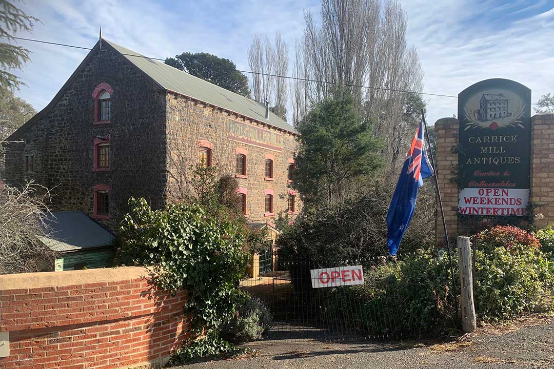
Carrick, on the banks of the Liffey River, is a small historic village. The Meander Valley Highway passes through the town's centre. Carrick has a well-preserved 19th-century heritage; fifteen of its colonial buildings are listed on the Tasmanian Heritage Register including Carrick House (1840), St Andrew's Church (1848), the Old Watch house (1837), Monds Roller Mill (1846) and the Carrick Hotel (1833).
More
14 km from Launceston (14 mins drive)
Hadspen is a small town that functions as a "dormitory suburb", an extension of the Launceston metropolitan area. Entally House lies on the town's west, across the rver. The town has a small shopping centre with a post office and service station, adjacent to a large caravan and cabin park. Development has been almost entirely residential and mostly on the northern side of Meander Valley Highway. Hadspen has grown without any area set aside for small commercial operations, a fact that has led to just a single shopping complex.

35 km from Launceston (30 mins drive)
Located 34 km south west of Launceston, Cressy is a small, attractive, and historically significant town which came into existence in the 1850s to service the surrounding wheat farms. It was named after a land grant which was taken up in 1826 by a British company which had been formed to exploit Van Diemen's Land's agricultural potential. This substantial wheat farm prospered until 1856 when it was broken up. It was around this time that a distinctive settlement emerged.
More

41 km from Launceston (35 mins drive)
Deddington is a village on the Nile River and lies in the foothills of Ben Lomond near Evandale. There not a lot at Deddington, and were its name spelt slightly differently, one could say it was appropriately named, however Deddington was a hotspot of the Black Wars which saw the decimation of Aboriginal Tasmanian culture; its early pioneers played a role not only in the development of present day Central North Tasmania, but also in the establishment of the city of Melbourne.
More

Lymington St Peters Church, Nile
31 km from Launceston (27 mins drive)
The village of Lymington, later re-named Nile was established by local landowners James Cox of "Clarendon" and Donald Cameron of "Fordon" to house their Workers. Nile is located about 10 kilometres south-west of the town of Longford. Nile once had two licensed premises and two mail coaches that ran between Lymington and Launceston, Aytons & Hanneys. Today, its Georgian buildings include homesteads such as Strathmore, Old Fordon and Kingston. St Peters Church (1853) was originally used as a "School on Weekdays and a Chapel on Sundays". The Building was erected by James Cox (1790-1866) and stands on three acres of land also given by him. In 1869 the Local Schools Board visited the school and reported that there were 44 children enrolled but only 39 in attendance being 18 boys and 21 girls.

46 km from Launceston (32 mins drive)
10 km north-west of Conara Junction, Epping Forest is a rural locality on the South Esk River. The name was given to the area on 6th December 1811 by Gov. Lachlan Macquarie, when he spent the night there "at the northern extremity of Macquarie Plaims at the edge of Epping Forest". The township was originally named 'Epping' only. Since the 1820s it has been home to numerous cropping/grazing properties, such as Fairfield, a 2-storey homestead on a 1,417 hectare property that enjoys 8km of frontage to the South Esk River.
More

53 km from Launceston (37 mins drive)
The village of Cleveland, 5 km north west of Conara Junction, was established in 1842 as a stopping point on the coaching route between Hobart and Launceston. It is said that in its early years, Cleveland was a gathering point for travelers before they ventured onward through the dangers of Epping Forest, a notorious area for bushrangers. A convict station accommodating up to 100 prisoners at a time was built in 1839 as a serving station to build and repair roads in the area. Cleveland was originally planned as a large town, similar to what Campbell Town is today, but it never eventuated.
More

57 km from Launceston (41 mins drive)
The village of Conara used to be very well known by travellers on the Midland Highway, though very few knew its name. What caught their attention was what they called "the disappearing house". Standing at the turnoff to St Marys at Conara, the so-called “Disappearing House” earned its name by the illusion of its sinking into the ground as travellers approached along the main road from Hobart to Launceston, due to the peculiar conformation of the landscape.
More
69 km from Launceston (48 mins drive)
133 km from Hobart (1 hr 36 mins drive)
Once one of the early coaching stops between Launceston and Hobart, Campbell Town is nestled on the banks of the Elizabeth River on the main road between Hobart and Launceston. The town has an impressive collection of colonial buildings from the Georgian era. Campbell Town has a number of great eating placeas, and a great roadside park for kids to run around and burn up some energy.
More

Tap on image above again to hide this section.

For several thousand years this land formed part of the country of the Palawa people. For several thousand years this land formed part of the country of the Palawa people. In 1804 British colonization of northern Van Diemen’s Land began with the arrival of a party of officials, soldiers and convicts under Lieutenant Colonel William Paterson to establish the town of Launceston at the head of Port Dalrymple, as the Tamar estuary was then called.
First coming across the Norfolk Plains after the establishment of Port Dalrymple in about 1804, British settlers began taking up farming land in earnest in 1813. The primary stakeholders in the area at the time of establishment included the Cressy Company (formerly known as The Establishment) as well as the Archer Family. The Cressy Company and the Archer family transformed Norfolk Plains into an area that supported the whole of Australia at the time. By the mid 19th century, it had developed into the bread basket of Australia, growing wheat, the barley, and all the crops they needed, as well as well as grazing sheep and cattle.
The Norfolk Plains got its name from the Norfolk Islanders who had been relocated to Tasmania from Norfolk Island from between 1806 and 1808, to encourage them to take roots in the area. Most failed to see the area's potential and moved on. Norfolk Island was settled in 1788, abandoned in 1814 and then re-settled in 1825. The connection between Norfolk Island and Tasmania’s Norfolk Plains has been obscured for many years until the recent World Heritage listing of the Australian Convict Sites shone fresh light on this lost world.
Governor Lachlan Macquarie instructed Surveyor General Meehan to mark out fifty farms of varying sizes at Norfolk Plains, and in 1813 the “Minstrel” and then the “Lady Nelson” arrived at Launceston with some 145 Islanders, who were taken upriver to their newly allocated farms on either bank of the South Esk River.
More


© Our Tasmania | Design and concept: Stephen Yarrow
Email Us | W3Layouts