Burnie Park
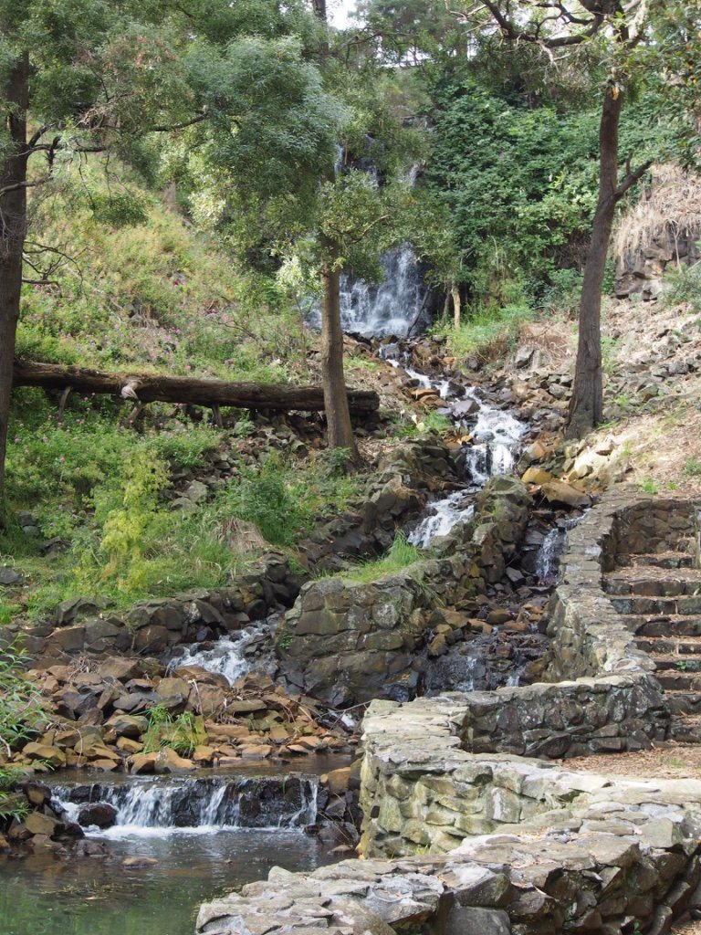
A 1.4 km walk from the city centre, Burnie Park fetures a pleasant walk through the manicured gardens and lawns, as well as a walking trail through a strip of remnant forest to Oldaker Falls.

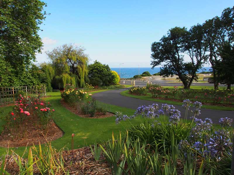
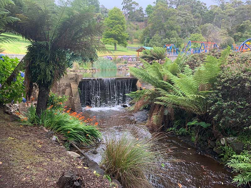
Just about every town and city has a park where one can go to relax and enjoy a little 'quiet time', but few are as pretty and enjoyable as Burnie Park. Located on the Bass Highway just west of the city centre, overlooking West Park Oval and Bass Strait, it features lush sweeping lawns, shady walkways and mature exotic trees. The Park is divided by a natural waterway - Stoney Creek - which adds greatly to its ambience. At the higher end of the park, away from Bass Highway, a walking trail winds its way through a rare stip of natural rainforest up to where the waterway tumbles over Oldaker Falls.
The ground was purchased by the Council in 1927 and originally formed part of an extensive private garden, but has evolved into much loved public space with pathways, spaces for reflection and community celebrations such as Easter Sundays Kids in the Park and Carols by Candlelight celebrations. Modern playground equipment is provided as well as free barbecues.The park features seasonal annual garden beds and a developed landscape, with numerous exotic and native trees and abundant lawns for passive recreation.
The history of Oldaker Falls dates back to 1876-1927 when William Henry Oldaker had a farm 'Avon' here and later a guest-house. Oldaker Falls is on Shorewell Creek, also known as Stoney Creek. Oldaker once worked for Sir Richard Dry at Quamby Estate, Hagley. He married Mary Turnbull of Glenore in 1857. In 1876 he sold his share at Quamby and moved to Burnie district and became a prominent citizen with a considerable acreage of land. After his death, the property was bought by the Municipality for the creation of Burnie Bark.
The Burnie Inn, now located in Burnie Park, is the only building remaining from the pre-1870 construction period and was located originally in Marine Tce where Centrelink stands today. It was Burnie's first licensed premises. The Inn was built by Joseph Law and opened in 1847 under the misnomer the Birnie Inn, following a clerical error. Law renamed it and it became the Burnie Inn in 1851 with Law as the licensee until 1855. In 1973 it was transferred to the park and opened as tea-rooms.

Subsequent publicans were Henry Redgate and William Parker each being mine host for a year until Thomas and Harriet Wiseman took over the license in 1856 for 2 years. It was replaced by a larger brick building adjacent to it in 1901 and later became a shop. It was marked for demolition until in 1973 a group of local citizens argued for its preservation and removal to its current site.
Burnie Park is also home to Burnie War Memorial, which commemorates those from the district who died in service or were killed in action during World War One. Money was raised by the Fallen Soldiers` Memorial Committee to construct the monument. The monument itself is a granite obelisk. The foundations are of columnar basalt, obtained from the quarry in the vicinity of the Burnie wharves.
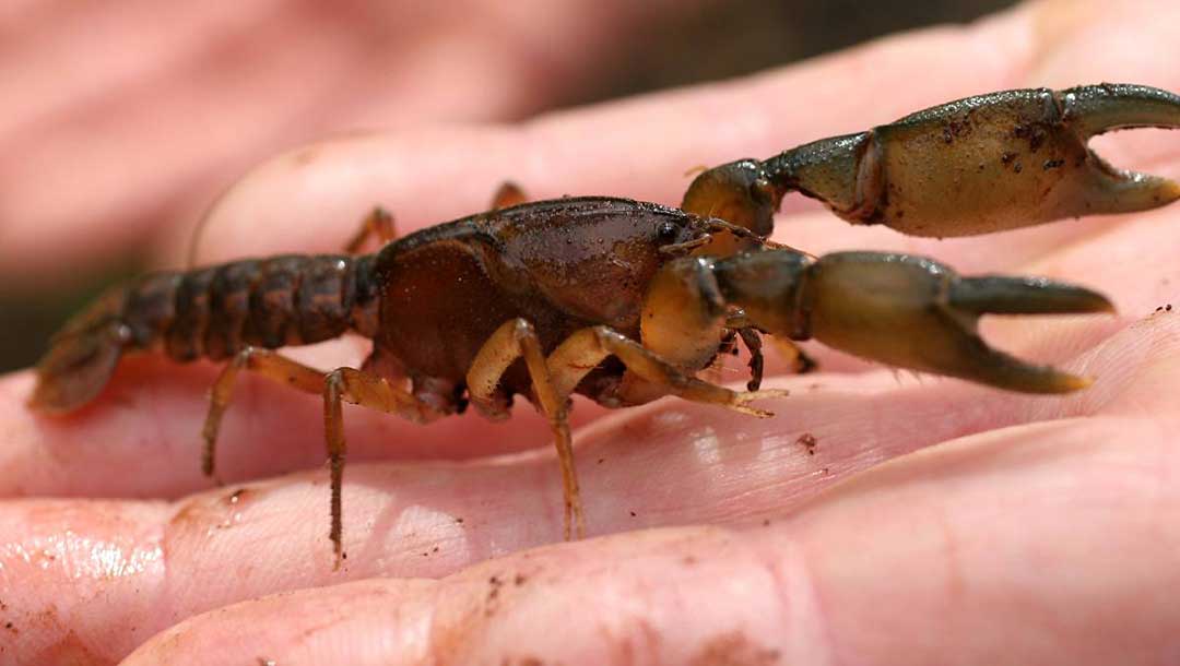
For many years Burnie Burrowing Crayfish (Engaeus yabbimunna) were a common site along Stoney Creek, which flows through Burnie Park. The endangered creature is a small to medium-sized burrowing freshwater crayfish, typically reaching a length of around 6 cm. The species is endemic to Tasmania, occurring over an area of approximately 130 square km in and around the city of Burnie. The Burnie Burrowing Crayfish is found in fern-dominated stream-side vegetation as well as in open and grassy sheep pasture, farm dams, roadside seeps and culverts, and sedgey marsh. The main threats to the Burnie Burrowing Crayfish include any activities which destroy or degrade the species' stream-side habitat, including such things as urban and agricultural pollution involving herbicides and pesticides, water diversion, forestry activities, roading and mining, and high-intensity burning of streamside habitat.
The known range of the Burnie Burrowing Crayfish includes an area of approximately 130 square km in and around the city of Burnie, north-west Tasmania. Known localities include Burnie Park, Shorewell Creek, Romaine Creek and the eastern arm of Cooee Creek (all in urban Burnie), plus several localities to the west of Burnie including Seabrook, Camp Creek, Distillery Creek, and a small tributary of the Cam River.


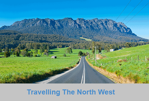
North West Coast
The North West coast extends from Burnie all the way west to Cape Grim, Tasmania's rugged north-west corner. Along the way are the beachside towns and villages of Wynyard, Boat Harbour Beach, Stanley and Smithton, as well as the rugged volcanic headlands od The Nut (Circular Head), Rocky Cape and Table Cape.
Full Itinerary


Central Coast
The first European settlement of Tasmania's Central Coast commenced in the 1840s, the rich basalt soil proved ideal for cropping, and today agriculture is the principal contributor to the area’s economy. Motorists travelling along the north-west of Tasmania are well served by the National Highway. Central Coast, however, is fortunate to have retained a small section of ‘old highway’. This scenic coastal detour hugs the headlands and sandy shores from Ulverstone through to Howth and is well worth the extra time taken to travel this scenic route.
Full Itinerary

Central Hinterland
Boasting rolling farmland, the hinterland of Tasmania's central coast is home to some of the region's finest agriculture and local produce, its narrow roads making their way through lush farmlands on their way to the alpine terrain of Cradle Mountain. The area is world-renowned for its bush-walking, mountain ranges and canyons, and laid-back small towns set againt mountainous backdrops.
Full Itinerary

North West Hinterland
The area is dominated by the Tarkine, a wilderness area containing a wildly diverse landscape, a world of natural treasures including Australia's largest patch of temperate rainforest, mountain ranges, wild river and cave systems and buttongrass moorlands. Waterways can be explored by canoe, kayak and riverboat cruises through forests of blackwood, myrtle and celery top pine all the way to the sea.
Full Itinerary

Meander Valley
Set against the backdrop of the Great Western Tiers, the Mradner Valley is located at the western end of the Central Coasy Hinterland, located midway between Launceston and Devonport. Dotted among the farms of the area are numerous small towns, each with their own individual character and colonial-era charm. Deloraine, on the banks of the Meander River, has become a centre for artists and craftspeople, drawn by the lifestyle and inspired by the stunning scenery.
Full Itinerary

West Coast
2 to 3 hours drive from Devonport and Burnie, Tasmania's West Coast region is made up of serene natural harbours, rugged coast, densely forested mountain ranges, fast flowing rivers, steep gorges, rainforest wilderness and ghost towns. The region has some of the most pristine and beautiful wilderness in the world, encapsulated in the World Heritage listed Franklin-Gordon Wild Rivers National Park. Bushwalkers are rewarded by spectacular nature sights. Even the less energetic can enjoy the untouched rainforests while cruising the Gordon and Pieman Rivers.
Full Itinerary
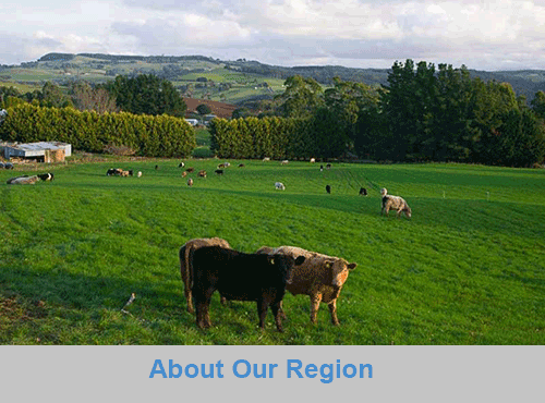
The North West region of Tasmania covers a vast area including the towns of Devonport, Burnie, Cradle Mountain National Park and the Tasmanian west coast as far south as Strahan and Queenstown. The gateway to this region is Devonport, with an airport and the Spirit of Tasmania (ferry between Victoria and Tasmania) terminus. The port handles much of the export produce from the rich agricultural areas around Devonport. The town itself is used as an arrival or departure port for most travellers rather than a destination itself.
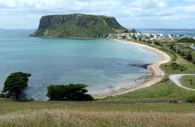
A major farming area stretches from Devonport along the coast to Stanley. Many of Australia's finest vegetable and dairy produce come from this region. Stanley is an historic fishing village with a large volcanic headland - The Nut - accessible by chairlift. Far out to the north-west in the stormy waters of Bass Strait, King Island consists very much of uninhabited bushland teeming with wildlife. The island produces some of the best dairy products, for which it is famous.
Cradle Mountain-Lake St Clair National Park, in Tasmania's World Heritage Wilderness Area, offers a rugged environment with many wilderness retreats and walking tracks. Icy streams, ancient pines, glacial lakes and wildlife surround the jagged contours of Cradle Mountain. The area is one of the most glaciated in Australia and includes Tasmania's highest mountain, Mt Ossa (1617 metres) and Lake St Clair, Australia's deepest natural freshwater lake, the source of the River Derwent.
The West Coast area of Tasmania is made up of rugged coast, mountain ranges, flowing rivers, steep gorges, rainforest wilderness and ghost towns. Strahan is situated on Macquarie Harbour and is the starting point for Gordon River cruises and air tours over the South West Wilderness. Strahan is the only town on this rugged and dangerous coast.