
Sorell, Tasmania

Sorell is located on the Tasman Highway at the junction with the Arthur Highway, to the east of Hobart. Sorell is one of Tasmania's oldest towns, being first settled in 1808 as a small farming community and becoming an official township in 1821. Historically, it was known as a major town on the route from Hobart to Port Arthur on the Tasman Peninsula. It was the centre of an agricultural area and an important market town. It is now a dormitory town of Hobart, as well as the seat of the Sorell Council.
From its early days, Sorell rivalled Richmond in importance in the south-east region. Unfortunately, much of its original heritage has been long since demolished or removed. All that remains are three Blackburn-designed churches (all classified by the National Trust and listed on the National Estate), and several other smaller buildings in the township itself.

Sorell was named after William Sorell (1775-1848), the third Lieutenant-Governor of Van Diemen's Land. William Sorell replaced Thomas Davey on 9 April 1817 with the colony in disarray. He reported that the island was in a 'long disordered state from a Banditti which has subsisted for years'. In his seven years as lieutenant-governor, Sorell cleaned up the colony and established the Macquarie Harbour Penal Settlement in 1821, a place for convicts who had committed secondary crimes in the colony and were in danger of becoming bushrangers. That settlement became a benchmark of punishment in the British Empire, playing a key role in keeping the convicts of Van Diemen's Land submissive. Sorell was recalled from hs role as Lieutenant-governor on 26 August 1823.

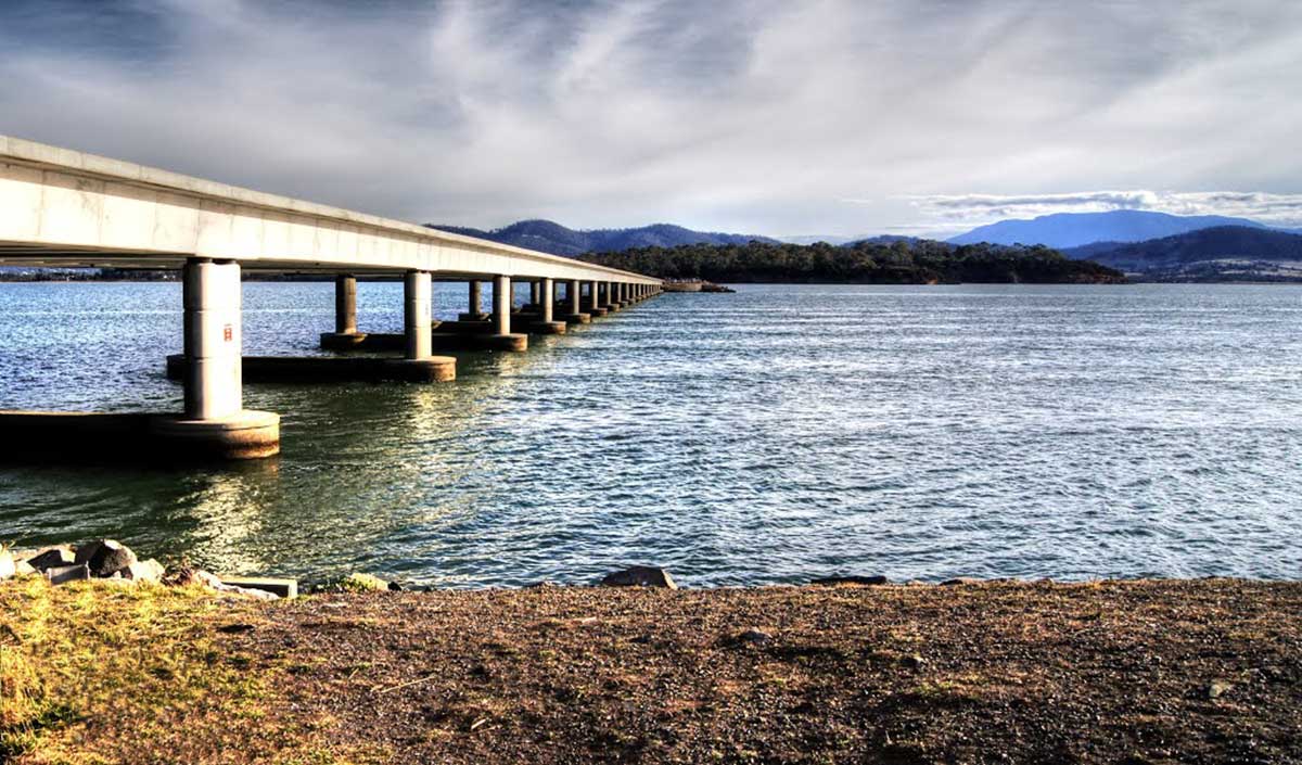
In 1872 the Sorell Causeway was opened, from the Cambridge direction, across Pittwt Water and Orielton Lagoon to Sorell, stopping at Midway Point in the middle. This shortened the route considerably from the original road via Richmond.
Pittwater
Pittwater is an almost landlocked body of tidal salt water with a narrow entrance to Fredrick Henry Bay. The whole area is protected by the large adjacent sand bar of Seven Mile beach. Most of the area is open water fringed by saltmarsh communities and rocky shores. The area includes a number of small islands upon which sea birds nest.
Pittwater is a major (northern winter) feeding ground for migratory, palaearctic wading bird species. It has particular importance because it is at the southern limit of the migration route. The avifauna is both abundant and species-rich with at least 21 species occuring. The rocky shores of Pittwater are the major habitat of the small, endemic sea-star Patiriella Vivipara. A saltmarsh research site is found at Railway Point in the west of the area.
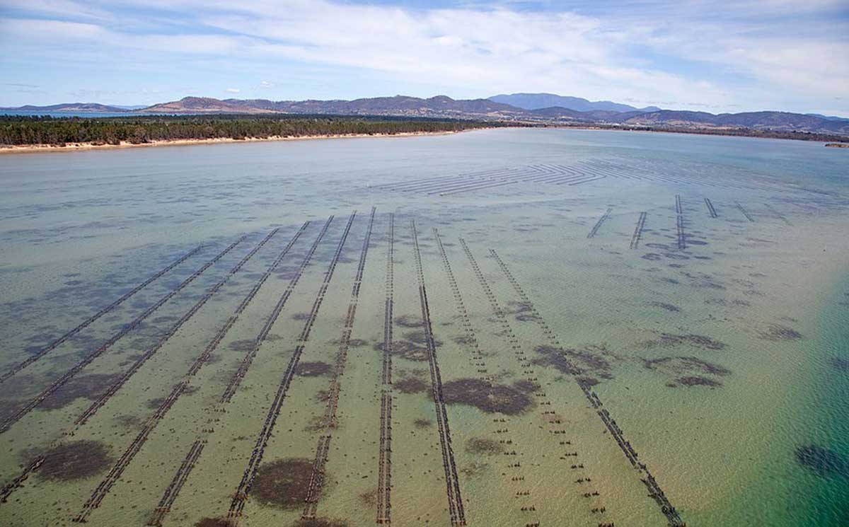
Pittwater oyster beds
Orielton Lagoon has been separated from Pittwater since 1868, when the causeway was constructed, restricting tidal flushing and creating a shallow lagoon. In 1995 additional culverts were created under the causeway allowing increased water exchange. Prior to this, seawater replenishment was only possible during high tides, and evaporation in the shallow (1.25 m) lagoon resulted in large changes in salinity.
Sorell Rivulet forms part of the Pittwater Arielton Lagoon Ramsar site. The Murimimina people of the Oyster Bay tribe were the original occupants of the area. The Sorell Rivulet contains many Aboriginal heritage and occupation sites as they utilised the area for resources and cultureal practices. All Aboriginal sites are protected under state and federal government legislation.
Heritage walks
There are a number of interesting heritage walks in Sorell and many old buildings from the colonial period have been preserved to the present day. These include:
The Barracks - Built 1827
St Georges Church - Built in 1828 - Rebuilt 1884
The old Post Office - Built 1840
Pembroke Inn - Built in the 1840s
Scots Uniting Church - Built 1842
The Gordon Highlander Hotel - Opened 1844
Police Magistrates House - Built 1848
St Thomas Catholic Church - Built 1864
Pelham House (Originally a Maternity hospital and Doctors Surgery) - Built 1864
Sorell Antiques Centre (Originally a Library) - Built in 1861
Railway House/Terminal - Railway opened 1892
Brief History
When Governor Macquarie named the town in June 1821, the district had already grown from the small farming settlement of a decade earlier, to a thriving wheat growing district of some sixty farms complete with a flour mill. In 1823, the town's population was 133 residents and of these 96 were convicts. Although details are sketchy, Sorell has a barracks building which was used in the early half of the nineteenth century until the time that police were stationed in the town. A court house and gaol were built in 1818 on the site where the Sorell Council Chambers now stands.
From the mid 1850s onwards, the town grew with businesses and public buildings to serve the local community. Sorell must have suffered from relative isolation until the 1870s. Before this time the residents relied on primitive ferries for crossing the Pittwater or had to journey via Richmond to Hobart. A causeway was completed in 1872, and by 1876 communications improved with the introduction of a telegraph service in 1876. The Bellerive-Sorell railway line was built in 1892. a number of residents in Sorell are descended from the community that lived and worked there early last century. In recent years, much of the town has been developed due in part to its close proximity to Hobart by car.
Sorell is fortunate in having a small but representative sample of buildings surviving from the various stages of its expansion last century. When examined together, these make Sorell intelligible as a nineteenth century farming village and it could be suggested, one that documents the evolution of a community from one with strong convict associations, to a respectable, church going and law abiding one.
The demolition of courthouses and gaol in 1910 and their replacement with a Council Chambers is almost symbolic of the town's desire to finally banish evidence of these origins and embrace a new civic consciousness. The remaining early Sorell commercial buildings include The Plough and Harrow Hotel of 1829, the Gordon Highlander Hotel, which was licensed from 1844 and the Pembroke Inn dating from the mid-nineteenth century. The public buildings are the Barracks, Railway House at the terminus of the Sorell-Bellerive Railway, and the Sorell District School which was built in 1821 but replaced by the present building in 1888.

The house at 28 Gordon Street was built by John Jackson in 1848 to rent to the Police Magistrate. Jackson also built numerous stone buildings in Macquarie Street, Hobart. The courthouse and gaol were erected in 1828 on a site which originally extended to the boundary of this property. The Sorell Council Chambers was constructed on the site of the courthouse and gaol in 1910. Neighbouring houses on properties on either side of the house are from a later period and are dated circa 1910 and 1890.
The early surviving nineteenth century buildings near the intersection of Gordon and Somerville Streets convey a sense of an early precinct of public and church buildings. These are the former courthouse and gaol site on which the Council Chambers stands, the site of the original Sorell District School, and St George's Anglican Church. The Pembroke Inn near the intersection was licensed for accommodation in 1847, specifically for one officer, two soldiers and one horse for H.M. Services.The genteel style of 28 Gordon Street, its general location and close proximity to the gaol and courthouse does suggest a relationship between the two sites and that the building was the residence for a government employee.
The house was classified by the National Trust as the Former Police Commissioners residence on 5 December 1983. It is mentioned along with other historic places in the town in the "Let's Talk About Sorell" brochure which was prepared by the Tasmanian Visitor Corporation and the National Trust. There have been suggestions in the local community that the house is associated with the bushranger, Matthew Brady and the artist, Houghton Forrest but no supporting evidence has been sourced.

There are three National Estate listed churches in Sorell. Built in 1826 and rebuilt in 1883, St George's Anglican Church is of a simple colonial gothic style, characterized by its gabled iron roof, with closed eaves and walls. The walls are made of coarse sandstone and have buttresses at regular intervals. As well as the church, there is an adjacent graveyard, featuring graves dating back to the 1830s, and grounds which now contains the Sorell Visitors Information Centre and a small park. Whilst the church is of a simple design, but up close the workmanship is outstanding.
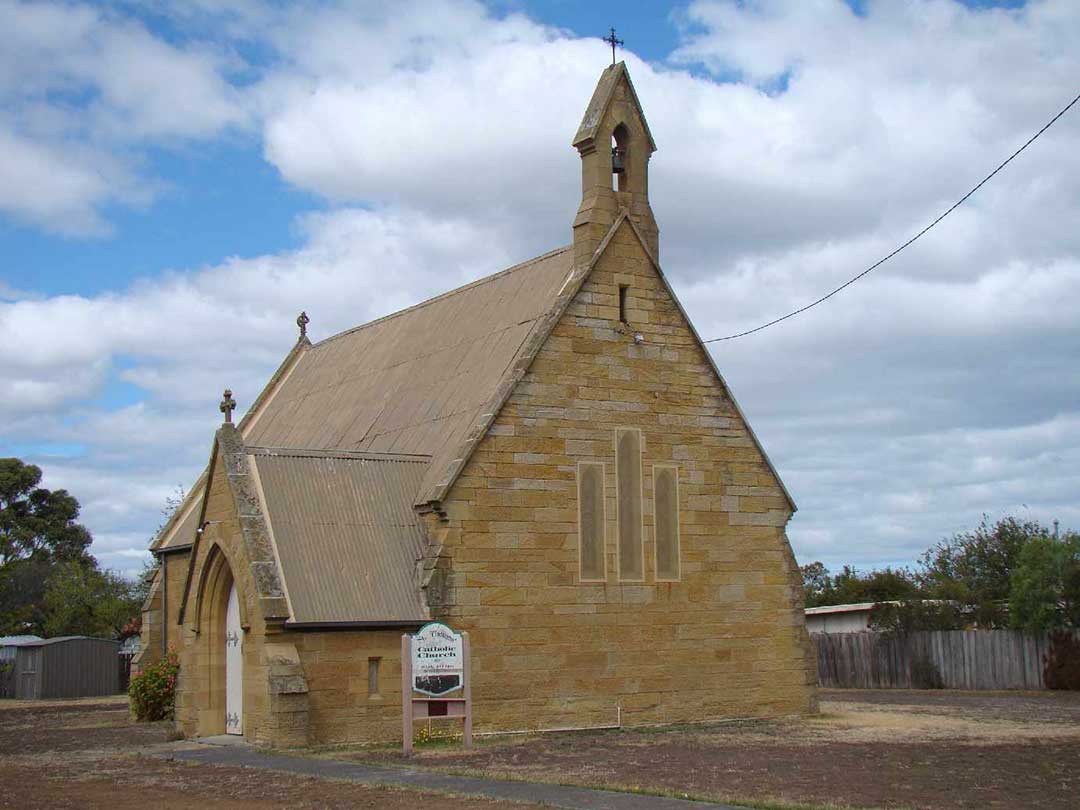
St Thomas Catholic Church, Gordon Street, Sorell
The Catholic community began to establish itself in Sorell from the late 1840’s and first requested the government for an allotment on which to build a church in 1850. The Hobart Bishop Wilson also requested four lots for a minister’s house, a school and other church purposes as well as a burial ground. Work was begun in 1863 with the foundation stone laid in 1864 and was completed the same year (1864), enabling the church to be opened amid great fanfare by Bishop Wilson in January 1865. The church continues to serve the local Catholic community to this day.
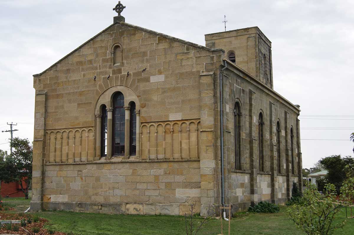
Former Scots Uniting Church, Arthur Street, Sorell
Sorell’s former Uniting Church was established as a Presbyterian Church in the early 1840s. The foundation stone for the church was ceremonially laid on Thursday 16 July 1840 and the building was completed almost two years later, opening on Sunday 24 April 1842. The land for the church had been donated by Andrew Counsel and the architect was James Blackburn. Difficulties in securing regular services of a minister resulted in the church being unused for many years and the building fell into disrepair. The irregular use of the church resulted in it becoming a target of vandalism.
The church was used by the Anglicans between 1879 and 1884 after St George’s was declared unsafe and was torn down and rebuilt. Ministerial shortages continued to impact on the church through to the 1920s. It was restored in the early 1960s by a group of volunteer workers with funding from the National Trust and State government. The building subsequently received heritage classification by the National Trust. The church is described in the National Estate Register as "A sandstone Romanesque Revival church. The total cost for the finished church was 1415 pounds which came from public donations and via government contribution with the bell for the new church being donated by local land holder, George Marshall. An unusual stone church which is a fine example of Blackburn's work."
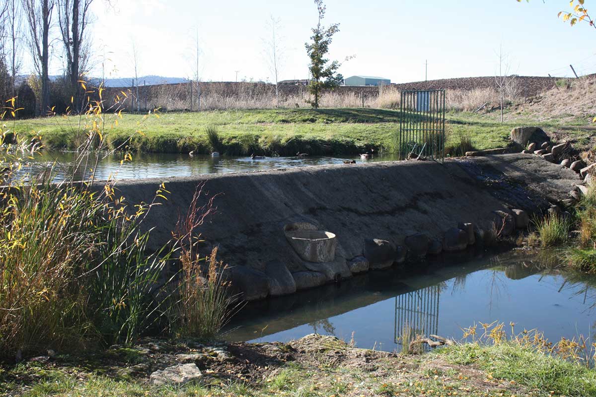
The Weir, Pelham Street, Sorell
The weir was constructed in the early 1880s and was used between 1882 and 1926 as a source of water, to supply steam trains which operated into and out of Sorell during that period. It is the sole remaining historical evidence of the train service to Sorell. The weir is of concrete and rubble construction, approximately eight metres in length, three metres wide at the base and less than one metre wide at the top. The weir is on the Sorell Rivulet adjacent to Pelham Street, bordered on one side by Pioneers Park Recreation Reserve (eastern bank) and on the other by a caravan park (western bank).
Sorell Railway Station
The 24 km Bellerive to Sorell Railway was built to link Hobart to the east and south east areas of Tasmania. Construction of the line commenced in 1890. The line had a relatively short life, being closed in 1926 as a result of declining traffic and high maintenance costs. It was nicknamed the "Idiotic Railway" by many, including vocal antagonists and politicians, in reference to a time when state governments were excessively constructing railways around Tasmania regardless of costs. The railway included several interesting features: a 164 metre long stone-lined tunnel (the oldest railway tunnel in Tasmania; no public access); a 256 metre long stone causeway; a 582 metre long timber viaduct; and the 400 metre long Shark Point cutting.
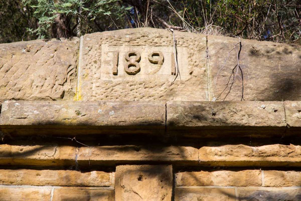
Stonework above a tunnel portal, inscribed "1891"
The line commenced on a wharf extending into Kangaroo Bay, Bellerive, part of which is still in place between the Bellerive Yacht Club and the adjacent park area, which is roughly where the goods yard was located. A passenger ferry service operated between the wharf and Hobart city. Cambridge was the location of the major intermediate station on the line. Signs of the old route are visible in paddocks around the town area. From Shark Point to Sorell, much of the line is now the route of Shark Point Road, and the Sorell yard area is still fairly open in the area around Station Street, with some being used by the local council. The Sorell station building, although somewhat modified, is now an antique shop. The Sorell carriage shed survives as the local council depot. Some pieces of rolling stock are preserved at the Tasmanian Transport Museum, Glenorchy.
Section of the railway aligment are walkable. A brass plaque marks the railway right-of-way about one kilometre from Sorell. Cambridge station yard still exists, the white level crossing gate is original, the railway station still stands on its original site, but the building has been heavily modified.
Railway Walking Trail >