Oakleigh Park
15 mins each wayOakleigh Park, alongside Burnie's business centre, is regarded as the birthplace of Burnie and cradle of the north west coast because the Van Diemen's Land Company's chief surveyor, Henry Hellyer camped there in 1827 and seected it as the site for the company's port.


Oakleigh Park, close to Burnie's business centre is regarded as the birthplace of Burnie and cradle of the north west coast because the Van Diemen's Land Company's chief surveyor, Henry Hellyer camped there in 1827. With the company chief agent, Edward Curr's later agreement, Hellyer decided that Burnie's Emu Bay, which Oakleigh Park overlooks, should be the port servicing the company's tracts of land at Hampshire and Surrey Hills fifty kilometres inland around St Valentine's Peak. Hence, part of Oakleigh Park's cultural significance is historical.

This event is symbolised by a slender column of pink granite, and a plaque unveiled in the sesquicentenary year 1977. The park is a 0.5km walk from the City centre and features picnic seating and tables, playground equipment, a fountain and sundial. The park was named after a house known as 'Oakleigh' built for the Van Diemen's Land Company's Emu Bay overseer. It stood near the area from the early 1840s until it was demolished in 1962.

Emu Bay
Oakleigh Park was originally on the shores of Emu Bay, but reclamation on its western shore for the construction of Burnie's port facilities and road access into the city via Bass Highway has resulted in it being landlocked. The bay was named by Henry Hellyer, presumably because of the many Tasmanian Emus that were common in the area in Burnie's early days.
Like the Tasmanian Tiger, there are no emus in Tasmania any more as it is now extinct. The Tasmania Emu, after which the river and the bay on which Burnie stands were named, is believed to have been a smaller sub-species of the mainland emu. The external characters used to distinguish it were its whitish instead of a black foreneck and throat and an unfeathered neck.
The Tasmanian Indigenous people’s sustainable relationship with the emu also suggests emu population numbers were significant. The Tasmanian emu was regularly symbolised in Indigenous art, in their ceremonies it was common practice for Tasmanian Aborigines to dance and characterise emus by stretching out one arm to emulate the long neck of the bird. Feathers were used to decorate inside Aboriginal huts, and served as insulation and floor coverings.
The indigenous people used a substance called ‘patener’, made from a ground metal mixed with emu fat/oil, to mark their heads and bodies. Emus featured in stories and songs, and there were many different names for them, including gonanner, ponanner and tooteyer. There are many references to the emu in early colonial records too, with many place names recalling it, eg. Emu Hill, Emu Heights, Emu Point.

A watercolour by William Porden Kay depicts emus at Stanley during the 1840s. (Allport Library and Museum of Fine Arts, State Library of Tasmania)
Like the Tasmanian Aborigines with whom it had co-existed for thousands of years, the Tasmanian emu suffered a calamiltous fate with the arrival of white man. By the time of Henry Hellyer's encounter with emus at Emu Bay in 1827 when he named the bay after them because of their significant numbers, southern Tasmania's emu population was already in decline and within 40 years the species would be extinct. Though Emu Bay was once a stronghold for these flightless birds, their populations also diminished quickly after white settlers moved in. When the Burnie settlement was surveyed in 1846, the Tasmanian Emu was almost gone. The species survived in the wild until 1865, and the last captive bird died in 1873.
During those years, land was being cleared at an astronomical rate. The emu's habitat was quickly destroyed to make way for grazing land for sheep. By 1840, there were 280,000 sheep in Tasmania.
The introduction of dogs is also considered a major contributing factor to the fast extinction of the Tasmanian emu. Though it was a really important food source for the Aboriginal people who hunted emus, it was in relatively low numbers. Emus were pretty hard to catch, they were fast runners and could defend themselves. That all changed with the introduction of the domestic dog. Prior to the arrival of Europeans, Van Diemen’s Land did not have a domestic dog, nor was the dingo present. But the Europeans had dogs and guns and that combination proved deadly for the emu and hastened its extinction.

Emu Bay


North West Coast
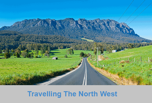
The North West coast extends from Burnie all the way west to Cape Grim, Tasmania's rugged north-west corner. Along the way are the beachside towns and villages of Wynyard, Boat Harbour Beach, Stanley and Smithton, as well as the rugged volcanic headlands od The Nut (Circular Head), Rocky Cape and Table Cape.
Full Itinerary


Central Coast
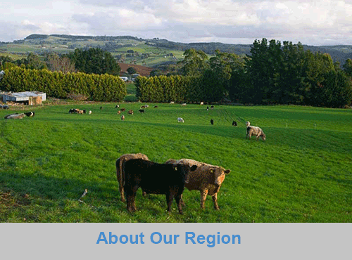
The first European settlement of Tasmania's Central Coast commenced in the 1840s, the rich basalt soil proved ideal for cropping, and today agriculture is the principal contributor to the area’s economy. Motorists travelling along the north-west of Tasmania are well served by the National Highway. Central Coast, however, is fortunate to have retained a small section of ‘old highway’. This scenic coastal detour hugs the headlands and sandy shores from Ulverstone through to Howth and is well worth the extra time taken to travel this scenic route.
Full Itinerary

Central Hinterland
Boasting rolling farmland, the hinterland of Tasmania's central coast is home to some of the region's finest agriculture and local produce, its narrow roads making their way through lush farmlands on their way to the alpine terrain of Cradle Mountain. The area is world-renowned for its bush-walking, mountain ranges and canyons, and laid-back small towns set againt mountainous backdrops.
Full Itinerary

North West Hinterland
The area is dominated by the Tarkine, a wilderness area containing a wildly diverse landscape, a world of natural treasures including Australia's largest patch of temperate rainforest, mountain ranges, wild river and cave systems and buttongrass moorlands. Waterways can be explored by canoe, kayak and riverboat cruises through forests of blackwood, myrtle and celery top pine all the way to the sea.
Full Itinerary

Meander Valley
Set against the backdrop of the Great Western Tiers, the Mradner Valley is located at the western end of the Central Coasy Hinterland, located midway between Launceston and Devonport. Dotted among the farms of the area are numerous small towns, each with their own individual character and colonial-era charm. Deloraine, on the banks of the Meander River, has become a centre for artists and craftspeople, drawn by the lifestyle and inspired by the stunning scenery.
Full Itinerary

West Coast
2 to 3 hours drive from Devonport and Burnie, Tasmania's West Coast region is made up of serene natural harbours, rugged coast, densely forested mountain ranges, fast flowing rivers, steep gorges, rainforest wilderness and ghost towns. The region has some of the most pristine and beautiful wilderness in the world, encapsulated in the World Heritage listed Franklin-Gordon Wild Rivers National Park. Bushwalkers are rewarded by spectacular nature sights. Even the less energetic can enjoy the untouched rainforests while cruising the Gordon and Pieman Rivers.
Full Itinerary
The North West region of Tasmania covers a vast area including the towns of Devonport, Burnie, Cradle Mountain National Park and the Tasmanian west coast as far south as Strahan and Queenstown. The gateway to this region is Devonport, with an airport and the Spirit of Tasmania (ferry between Victoria and Tasmania) terminus. The port handles much of the export produce from the rich agricultural areas around Devonport. The town itself is used as an arrival or departure port for most travellers rather than a destination itself.
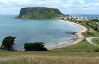
A major farming area stretches from Devonport along the coast to Stanley. Many of Australia's finest vegetable and dairy produce come from this region. Stanley is an historic fishing village with a large volcanic headland - The Nut - accessible by chairlift. Far out to the north-west in the stormy waters of Bass Strait, King Island consists very much of uninhabited bushland teeming with wildlife. The island produces some of the best dairy products, for which it is famous.
Cradle Mountain-Lake St Clair National Park, in Tasmania's World Heritage Wilderness Area, offers a rugged environment with many wilderness retreats and walking tracks. Icy streams, ancient pines, glacial lakes and wildlife surround the jagged contours of Cradle Mountain. The area is one of the most glaciated in Australia and includes Tasmania's highest mountain, Mt Ossa (1617 metres) and Lake St Clair, Australia's deepest natural freshwater lake, the source of the River Derwent.
The West Coast area of Tasmania is made up of rugged coast, mountain ranges, flowing rivers, steep gorges, rainforest wilderness and ghost towns. Strahan is situated on Macquarie Harbour and is the starting point for Gordon River cruises and air tours over the South West Wilderness. Strahan is the only town on this rugged and dangerous coast.