Railways of Tasmania

Hobart's Lost Railways
The story of Hobart's railway and tram history.

Burnie's Railway History
Burnie Railway Station was the terminus for a regional railway network for both commercial and passenger trade.

The Tasman Limited
The Story of Tasmania's Inter City rail service.

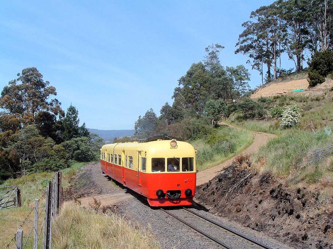
Don - Melrose Railway
To get the timber out of the bush, a tramway was built up the Don valley, and from 1862, the line also served a small coal mine, situated about 3km above the mill.

North East Railway
The Launceston-Scottsdale line was opened in February 1889 and passed through twelve stations along the way. The railway was extended to Branxholm in 1911, and later, Herrick. The last operational section was closed in 2004.
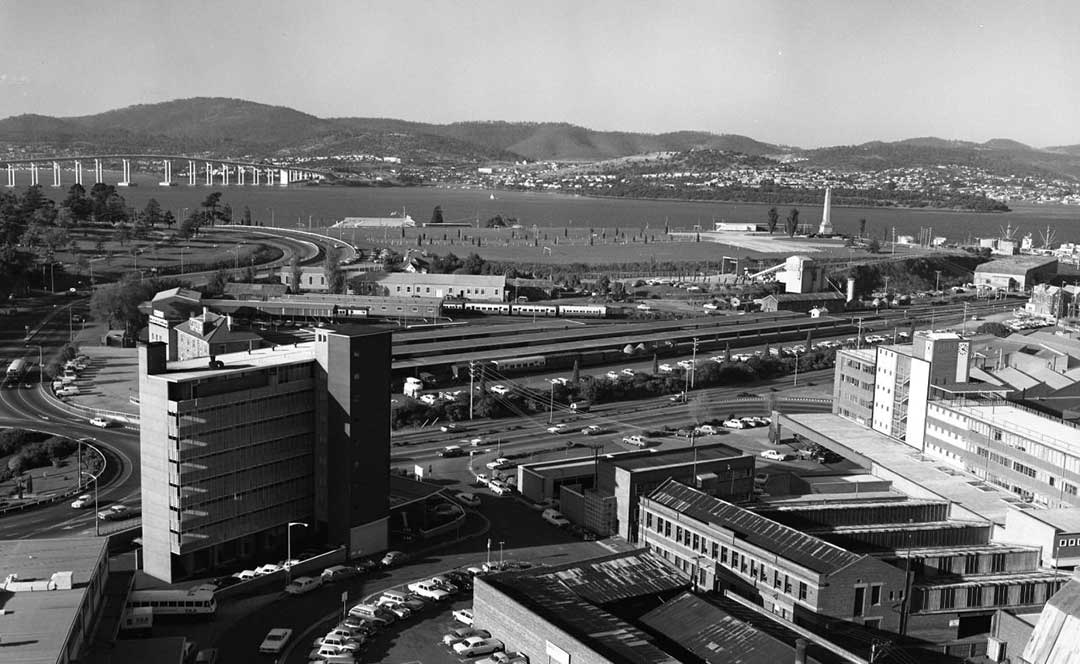
Hobart Railway Station c. 1964-1975
Hobart's Lost Railways
The Tasmanian Main Line Railway Company (TMLR) opened its line from Hobart to Evandale Road (later Western Junction) in 1876. The railway reduced travelling time between Hobart and Launceston from at least fifteen hours (by coach) to seven. The main Tasmanian system reached its heyday in the 1930s and 1940s, radiating from its Launceston headquarters and extensive workshops at Inveresk, south to Hobart and the Derwent Valley, north-east to Herrick, east to St Marys and north-west to Marrawah.
In its day, the Tasmanian Government Railways was a major employer, offering a huge range of jobs: train crew, tradesmen, engineers, apprentices, fettlers, signalmen, clerks, braided stationmasters and ubiquitous 'lad porters'. Apart from goods of every description, the railways carried passengers to factories, schools, the Royal Show and on excursions. For the first time, the railway enabled ordinary people to travel for holidays or pleasure. The rail passenger service between Launceston and Hobart became known as the Tasman Limited.
A suburban train passing through Claremont
In common with many railway systems, Tasmania's was of necessity exploited by overuse and under-maintenance during the Second World War. By the 1970s passenger patronage was in such decline, there was insufficient revenue being generated to warrant upgrading Tasmania's passenger trains, and a decision was made to withdraw the service. The last passenger train from Wynyard to Hobart ran on 18th July 1978. The the ABC studios have been built on the site of the former Hobart railway station. Much of the passenger rolling stock went to the Tasmanian Railway Museum at Glenorchy, with some going to the Don River Preservation Railway based in Devonport. Hobart now has the second lowest public transport patronage in Australia and as a result is very much a car orientated city.
Riverline also known as the Northern Suburbs Railway is a proposed AU$100 million light rail system that would traverse the southernmost section of the South Railway Line, through the northern suburbs of Hobart. It would follow the narrow gauge railway corridor which starts at the city centre and travels north towards Bridgewater. Despite strong public support, the future of the proposed light rail remains uncertain due to a lack of political enthusiasm. The most recent proposed route being pursued by the state government commences at Mawson Place and ends in close proximity to the Museum of Old and New Art, within the suburb of Berriedale. proponents of the light rail have recently called on the state government to extend the transport corridor to North Hobart.
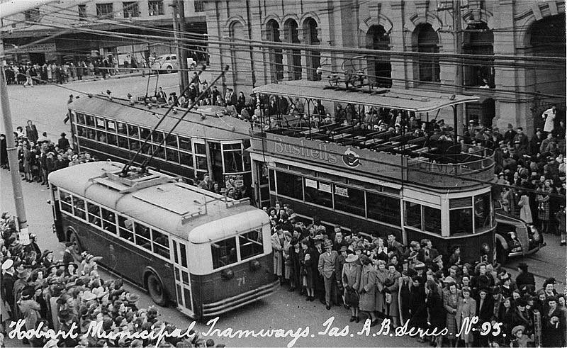
Hobart's trams and trolley buses
Hobart's tram network was built in 1893 and was the first completely electric network in Australia. The network consisted of eight routes throughout the city. In 1960, the tram service was decommissioned in favor of the trolleybus, although this service only lasted eight years and was replaced in 1968 by a motorised bus service. Hobart has investigated restoring the tram network, as it is part of its heritage, being one of the first Australian cities to implement a tram system but no such development has occurred.
DP 26 climbing up to Rhyndaston Tunnel. Photo: Steve Bromley
Hobart to Launceston Railway
The railway between Hobart and Launceston was built by the Tasmanian Main Line Railway Company and was officially opened on 1 November 1876. The route of the railway was selected largely as a result of vocal local interests and accordingly traversed some reasonably unfavorable topography, particularly in the southern section. Because the TMLR had limited finances, the line was built to the narrow (1067 mm) gauge and included long sections of steep gradients and sharp curves. The final eighteen kilometres of the route from Western Junction to Launceston used the existing broad gauge alignment of the Launceston and Western Railway, with a third rail being laid for use by the narrow gauge trains.
From its inception the line was known as the Main Line and carried this title until around 1978 when Australian National renamed it the South Line. Despite being in use for over 125 years, only limited deviations have been built and the line follows the original alignment. Track standards have been improved by the use of heavier rail welded into long lengths, steel sleepers and better ballast. The line remains in service, and sees multiple freight trains most days, these generally operating Burnie to Boyer and Burnie / Launceston to Hobart and return.
The Route: The line commences at Hobart station, which is nestled between the wharves and the Queens Domain on the edge of the city. The line follows the western side of the Derwent River valley to Bridgewater, where the river is crossed on a causeway and impressive lifting bridge. From here the line runs generally north east though easy country to Rekuna (between Tea Tree and Campania). From here the often steep and/or twisty climb commences, with little respite for train crews until Rhyndaston and its 1200m long tunnel is passed, some 28km later.
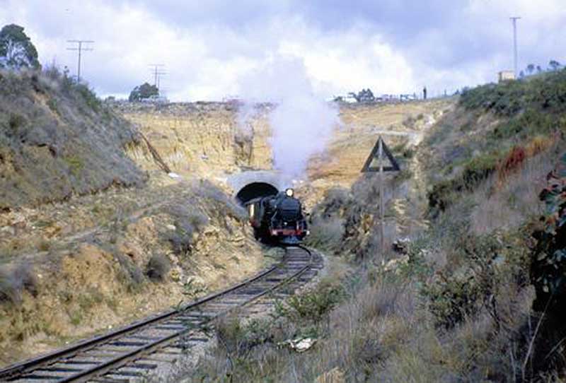
Rhyndaston Tunnel
The descent from near Parattah is not as steep or severe as its southern counterpart, although does still include a number of difficult sections including the Tin Dish and Nala deviations which were constructed in the 1930s to lessen gradients, although at the expense of more additional curvature in some sections. North of Antill Ponds, the line roughly parallels the Midland Highway as they both follow the agriculturally rich valley's formed by the Macquarie and South Esk rivers. The South Line finishes at Western Junction near Evandale, where it connects with the Western Line.