

Leven Canyon, Tasmania
Leven Canyon is a little-known tourist destination in Tasmania but well worth seeing. To get there, continue through Nietta and follow the signs to Leven Caynon. The canyon is a 250 metre deep ravine that is part of a wildlife corridor from the coast to Cradle Mountain. The Leven River runs through 300-metre limestone cliffs carved through the Loongana Range, down to Bass Strait. The viewing platform at Cruickshanks Lookout offers spectacular views of Black Bluff, the canyon itself and the surrounding areas. Black Bluff, directly opposite Cruickshank Lookout, is the region's first peak each winter to have a covering of snow, due to its exposure to the prevailing westerlies.

The Cruickshanks Lookout viewing platform is only a short walk from the car park and only regular shoes are required. The walk passes through a stunning stand of rainforest, complete with giant eucalypts, colourful fungi furtive wildlife, tree ferns and moss on the rocks, tree stumps and fallen timbers beside the path.

A second lookout, called edge, gives a different view of the canyon, and is reached on an optional loop walk. Between the lookouts there’s a steep set of stairs, which can be avoided if you return via the same track. The glade surrounding the car park is perfect for a picnic lunch - there are toilets, barbecue and picnic facilities with disabled access. Bring your own food and drink though, as the are no shops in the area - the last one you will have passed is the general store in Gawler.

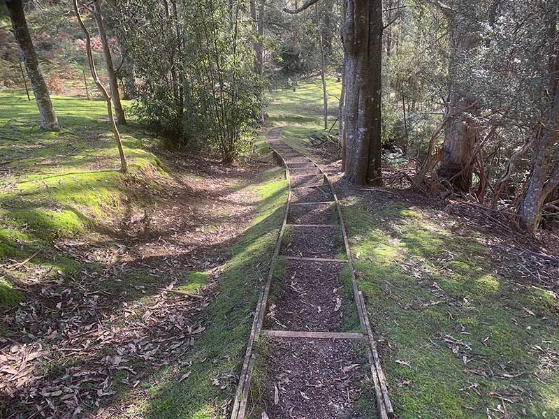
For the more adventurous, the Forest Stairs Track leads from Loongana Road all the way down into the canyon itself, almost to water level, to a bridge across the raging waters of the Levin River. Leven Canyon is Tasmania's deepest limestone gulch, with challenging terrain, so this is not a walk for anyone with health issues. The path, though well marked and constructed, is steep and there are 697 steps to negotiate in both directions. Experienced walkers can continue on to Devild Elbow, a challenging walk that is an hour return from the footbridge. The Forest Stairs Track in particular is subject to severe weather conditions all year round, and the weather may change quickly. At times the track can be difficult to navigate, and when covered in snow it may be impassable.
Enough water runs through the Canyon every day to satisfy the thirst of a major city. About 45,000 - 70,000 kilolitres of water flush through the Canyon daily, equivalent to water consumption for 350,000 people. Those who make it will be interested to know that the Canyon floor footbridge was made locally and components lifted in by helicopter. The Forest Stairs Track forms part of The Penguin Cradle Trail, a bush walking track developed by the North West Walking Club.

Canyon floor
The Cruickshanks Lookout viewing platform is only a short walk from the car park and only regular shoes are required. The walk passes through a stunning stand of rainforest, complete with giant eucalypts, colourful fungi furtive wildlife, tree ferns and moss on the rocks, tree stumps and fallen timbers beside the path.
A second lookout, called edge, gives a different view of the canyon, and is reached on an optional loop walk. Between the lookouts there’s a steep set of stairs, which can be avoided if you return via the same track. The glade surrounding the car park is perfect for a picnic lunch - there are toilets, barbecue and picnic facilities with disabled access. Bring your own food and drink though, as the are no shops in the area - the last one you will have passed is the general store in Gawler.
For the more adventurous, the Forest Stairs Track leads from Loongana Road all the way down into the canyon itself, almost to water level, to a bridge across the raging waters of the Levin River. Leven Canyon is Tasmania's deepest limestone gulch, with challenging terrain, so this is not a walk for anyone with health issues. The path, though well marked and constructed, is steep and there are 697 steps to negotiate in both directions. Experienced walkers can continue on to Devild Elbow, a challenging walk that is an hour return from the footbridge. The Forest Stairs Track in particular is subject to severe weather conditions all year round, and the weather may change quickly. At times the track can be difficult to navigate, and when covered in snow it may be impassable.
Enough water runs through the Canyon every day to satisfy the thirst of a major city. About 45,000 - 70,000 kilolitres of water flush through the Canyon daily, equivalent to water consumption for 350,000 people. Those who make it will be interested to know that the Canyon floor footbridge was made locally and components lifted in by helicopter. The Forest Stairs Track forms part of The Penguin Cradle Trail, a bush walking track developed by the North West Walking Club.
Canyon floor
Surrounding Area

Gunns Plains Caves
Gunns Plains
25 km northGunns Plains is a rich fertile area dotted with dairy farms, potato growing, poppy growing and beef cattle. In days gone by vegetables were grown here and it was also one of the three major hop producing regions in Tasmania. The Leven River winds slowly through its pastures that support a variety of grazing stock. Agricultural endeavours are also very successful, benefiting from rich red volcanic soil. The town was named after botanist Ronald Campbell Gunn, who visited the valley in 1860. Gunns Plains Caves are in the Gunns Plains State Reserve. The Reserve overlooks the beautiful Leven Valley farmland and has toilets, a wood barbecue and a shelter hut. A shop at Gunns Plains sells food and petrol.
Being approximately 30 kilometres south of Ulverstone in northwest Tasmania, Gunns Plains is easily accessible and a relatively short drive from both Burnie and Devonport. It is an ideal half day destination if you are short of time, however there is plenty to do if you devote a full day or more to explore the area. Camping, accommodation and refreshments are also available nearby.
More


Castra Road Scenic Drive
Castra Road (State Route B15) starts at Ulverstone and winds its way south through picturesque hills and farmland on its way to Nietta, a tiny village located about 44 kilometres south-west of the town of Devonport. Nietta is literally the end of the road. If approached from Devonport via Forth, Castra Road is joined at the village of Sprent. On the way you'll pass some of the prettiest dairy farming country you are ever likely to see.It has been said of the British that their home is their castle, which might explain the use of the word Castra by the early European settlers for the area they now called home in Tasmania. In the Roman Republic and the Roman Empire, the Latin word castrum (plural castra) was a building, or plot of land, used as a fortified military camp. In English, the terms Roman fort, Roman camp and Roman fortress are commonly used for castrum.
More

Silver Falls
Castra Falls Circuit
The Castra Falls Circuit near Upper Castra gives access to for waterfalls; Castra Falls, Silver Falls, Step Falls, and Secret Place. It is a grade 4 return hike which should take you approximately 2.5hrs to complete. Castra Falls is the second waterfall on the Castra Circuit. The track is commenced as an easy to moderate walk, progressively becoming more difficult the further you walk. It commences a few kilometres down Gaunts Road which is found on the way to Leven Canyon from Ulverstone.
Kaydale Lodge Gardens
Nietta
9 km north-eastNietta is a rural community situated approximately 30km south of Ulverstone. The Wilmot River forms most of the eastern boundary, and the River Leven forms much of the western. The B15 route (Castra Road) enters from the north and terminates at Nietta village. The name was used for a Parish from 1886. Nietta is an Aboriginal word meaning “little brother”.
A visit to Kaydale Lodge Gardens at Nietta is worth including on a trip to the area if you enjoy and appreciate the labours of those blessed with a green thumb. This 2ha garden has been a family obsession for the Crowdens of Nietta since parents Kay and Robert started it in 1979 from a bare paddock around the house Robert built. Using stone from their fields, they built walls and archways while running the cattle and cropping farm, raising their two daughters and establishing a business offering accommodation and meals. A small entry fee applies.

A PocketOz Travel and Information Guide
Design and concept © Stephen Yarrow | Email | W3Layouts | Test