
See and Do

26 km from Burnie (28 min. drive)
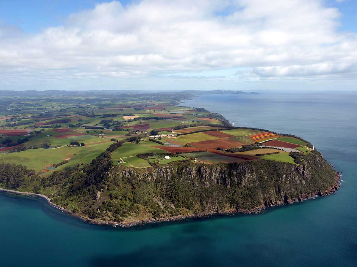
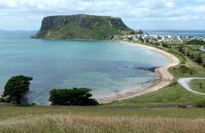
Table Cape makes for an impressive and dramatic backdrop for the town. Table Cape is a more or less circular volcanic plug with a flat top, its northern and eastern faces rise steeply from Bass Strait to a height of approximately 170 metres above sea level. Table Cape's top and surrounding areas are composed of fertile basalt soils and are heavily cultivated, the area is renowned for the annual flowering of tulips during spring and accompanying tulip festival. The 1.26 km2 Table Cape Conservation Area includes Freestone Cove and Fossil Bluff.
More


33 km from Burnie (30 min. drive)
Boat Harbour Beach may well be the most beautiful seaside village and beach in Tasmania. Furthermore, it exists in a microclimate which is removed from the surrounding weather patterns. Frosts are unknown and plants from the tropics can be seen in local gardens. It sounds like paradise. All the facilities one expects and needs surround the car park at the bottom of the hill. There are picnic and barbeque facilities on a grassed area, toilets and change rooms, a children's playground, a short walking path around the headland and a most delightful cafe by the water serving coffee, a snack or lunch.
More

39 km from Burnie near Boat Harbour Beach (37 min. drive)
Though just up the road (and the coast) from Boat Harbour Beach, Sisters Beach has a totally different look and feel. A quiet seaside village which extends some way along the waterfront, Sisters Beach is actually located within the Rocky Cape National Park and is situated on the old horse trail known as the Postman's Track that once formed the only connection between Emu Bay (now Burnie) and the Van Diemen's Land outpost of Stanley.
More

42.2 km from Burnie (45 mins. drive)
Rocky Cape National Park offers a fascinating variety of walks, ranging from less than 20 minutes to a full day. These take in Aboriginal rock shelters and caves, scenic hills full of wildflowers and birds, and tranquil beaches, bays and rocky headlands. From Sisters Beach there is a one hour walking ciruit to Wet Cave, Lee Archer Cave, returning via Banksia Grove, a stand of giant Banksia serrata. Sisters Beach is the only place in Tasmania where they occur. Although small, Rocky Cape National Park offers visitors a varied experience on Tasmania 's coast. Here you can learn about Aboriginal life on the north-west coast. Swimming, fishing, boating and walking are popular activities. Rocky Cape's unpolluted waters regularly attract dolphins and seals. At low tide on a calm day, the rocky foreshore reveals numerous rock pools inhabited by a variety of colourful fish and plants.
More

29 km from Burnie near Boat Harbour Beach (30 min. drive)
The Lobster Ponds Haven offers a unique experience to view and learn about the Giant Freshwater Crayfish (Astacopsis gouldi). Exclusive to Northern Tasmania, these extraordinary creatures are the largest crustacean in the world but are under threat by poaching and land clearing. The Lobster Ponds Haven also has a cafe and souvenir shop. 241 Robin Hill Road, Flowerdale.
More

47.6 km from Burnie (40 mins. drive)
Preston Falls, also Known as Delaney Falls, is a tall and slender 25m high waterfall which plunges over an alcove into the shady depths of the gorge. It is a short walk down steps to the overlooking platform. Due to the terrain, visibility of the waterfalls can only be seen from the side, from the top of the gorge. For a waterfall of this size, it was also one of the easiest waterfalls to visit in Tasmania. From the car park, the falls are at the end of a short 120 metre track through a pretty blackwood forest.
More

43.6 km from Burnie (41 mins. drive)
Wings Wildlife Park is a multi-award winning family owned business and displays the largest collection of Tasmanian wildlife in Australia. The Park is situated at Gunns Plains, 23 km south of Ulverstone, on the banks of the Leven River. The Park offers the chance to see some real live Tassie devils up close. The devil feed is at 1pm daily, koala presentation at 11am and 2.30pm, meerkats at 11.30am and 3pm and reptiles at 2pm. You can feed the trout and the friendly kangaroos. Other animals you can see at the park include wombats, wallabies, quolls, sugar-gliders, wedge-tail eagles, reptiles, meerkats, marmosets, monkeys, bison, camels and much more.
Website

48.1 km from Burnie (45 mins. drive)
Hellyer Gorge is the steeply winding gorge of the Hellyer River. The Murchison Highway passes through the area with many sharp and steep bends. A delightful wayside stop at the Gorge on the Murchison Highway south gives the opportunity for travellers to stop and explore a section of rainforest of tall myrtle beech, encrusted with mosses, fungi and epiphyte orchids. A number of walking tracks along the banks of the Hellyer River (near the rest area) provide a pleasant walk to refresh before journeying on.
More

45 km from Burnie (31 mins. drive)
Located on the outskirts of Devonport at the village of Don, The Don River Railway is one of the most enjoyable railway museums in Australia. Its focus is Tasmania's trains of yesteryear, and its sizeable display includes steam and diesel engines and other rolling stock that have played an important part in Tasmania's rail history. The extensive workshop is open for visitors to wander around and see trains in various stages of restoration. Don't miss the leisurely tourist train ride along the banks of the Don River to Coles Beach.
More

67 km from Burnie (58 mins. drive)
Leven Canyon is a 250 metre deep ravine that runs through 300-metre limestone cliffs carved through the Loongana Range, down to Bass Strait. The canyon is a little-known tourist destination in Tasmania. However, the viewing platform offers spectacular views of Black Bluff, the canyon itself and the surrounding areas. The viewing platform is only a short walk from the car park and only regular shoes are required. The canyon has barbecue and picnic facilities, and there are a number of walks in the general area.
More

31 km from Burnie (33 mins. drive)
This chain of mountains and valleys was given its name because the silhouette of one of its summits, the Gnomon, resembles an ancient sundial. Dial Range has numerous trails for bushwalking, mountain biking and horse riding. Two of the best places to visit are Ferndene and Mt Montgomery State Reserves. Ferndene Gorge State Reserve comprises 35.16 hectares (86.9 acres) and is managed by the Tasmanian Parks and Wildlife Service. There is a beautiful walk through the fern glade along a clear stream, surrounded by huge tree ferns reminiscent of Gondwana.
More

44 km from Burnie (42 mins. drive)
Gunns Plains is a rich fertile area dotted with dairy farms, potato growing, poppy growing and beef cattle. In days gone by vegetables were grown here and it was also one of the three major hop producing regions in Tasmania. Gunns Plains Caves are in the Gunns Plains State Reserve. The Reserve overlooks the beautiful Leven Valley farmland and has toilets, a wood barbecue and a shelter hut. A shop at Gunns Plains sells food and petrol. Gunns Plains is easily accessible and a relatively short drive from both Burnie and Devonport. It is an ideal half day destination if you are short of time, however there is plenty to do if you devote a full day or more to explore the area. Camping, accommodation and refreshments are also available nearby.
More

66 km from Burnie (56 mins. drive)
Lake Barrington is known as an international standard rowing venue and the site of the 1990 World Rowing Championships. It was created in 1969 by building the Devils Gate Dam on the Forth River. The lake is a popular water ski location with access via West Kentish and Wilmot. There are two water ski clubs based at Lake Barrington: Kentish Aquatic Club and Horsehead Water Ski Club. The lake is also used for canoeing and trout fishing. There is an adventure playground and a two-hour rainforest walk. Facilities for visitors include picnic sites, boat ramps and toilets.
More

29.5km from Burnie (30 mins drive)
Discover the enchanting Upper Natone Forest Reserve, a true haven for nature enthusiasts, located approximately 30 kilometers from Burnie, accessible via Stowport and Natone. This reserve offers a diverse display of natural wonders throughout the seasons.
The Upper Natone Reserve is not only a feast for the senses but also a popular recreational spot, providing amenities such as BBQs, picnic tables, toilets, a play area with swings, and the inviting Pat Crane shelter. Don't miss the opportunity to take a leisurely half-hour stroll along the scenic walking track through the forest and around the lake, surrounded by diverse native vegetation, for a truly rewarding experience. Open daylight hours.

Website

17.2 km from Burnie (19 min. drive)
Just outside of town is the turn-off to Guide Falls on the Guide River. Guide Falls Reserve is a popular picnic attraction with tables and bbq amenities located near the entrance of the reserve and further along the road at the top of the Guide Falls. From the lower picnic area it is an easy 5 minute walk to the bottom of the falls. It's an ideal setting to enjoy the peaceful sounds and gentle mist of water. There are relatively steep steps to the top of Guide Falls, where there is a viewing platform and the upper picnic area. A road which leads back down to the lower picnic area and entrance/exit.
More

St Georges Rd, West Ridgley
There are many falls in the Ridgley area and a few kilometres beyond Guide Falls are the Sanderson Falls and St Georges Falls.
The latter is a stunning waterfall that for a long time overlooked the wrecks of several cars that have been pushed off the falls. They have since been removed. Though only a short drive past Sanderson falls, there is no path leading to these falls, which are officially closed, so access is very much at your own risk. There is a old road leading very close to the bottom of the falls if you keep going south on the road at the top of the falls and keep taking tracks to the right it should take you there.
St Georges Falls information
The North West coast extends from Burnie all the way west to Cape Grim, Tasmania's rugged north-west corner. Along the way are the beachside towns and villages of Wynyard, Boat Harbour Beach, Stanley and Smithton, as well as the rugged volcanic headlands od The Nut (Circular Head), Rocky Cape and Table Cape.
Full Itinerary

The first European settlement of Tasmania's Central Coast commenced in the 1840s, the rich basalt soil proved ideal for cropping, and today agriculture is the principal contributor to the area’s economy. Motorists travelling along the north-west of Tasmania are well served by the National Highway. Central Coast, however, is fortunate to have retained a small section of ‘old highway’. This scenic coastal detour hugs the headlands and sandy shores from Ulverstone through to Howth and is well worth the extra time taken to travel this scenic route.
Full Itinerary

Boasting rolling farmland, the hinterland of Tasmania's central coast is home to some of the region's finest agriculture and local produce, its narrow roads making their way through lush farmlands on their way to the alpine terrain of Cradle Mountain. The area is world-renowned for its bush-walking, mountain ranges and canyons, and laid-back small towns set againt mountainous backdrops.
Full Itinerary

The area is dominated by the Tarkine, a wilderness area containing a wildly diverse landscape, a world of natural treasures including Australia's largest patch of temperate rainforest, mountain ranges, wild river and cave systems and buttongrass moorlands. Waterways can be explored by canoe, kayak and riverboat cruises through forests of blackwood, myrtle and celery top pine all the way to the sea.
Full Itinerary

Set against the backdrop of the Great Western Tiers, the Mradner Valley is located at the western end of the Central Coasy Hinterland, located midway between Launceston and Devonport. Dotted among the farms of the area are numerous small towns, each with their own individual character and colonial-era charm. Deloraine, on the banks of the Meander River, has become a centre for artists and craftspeople, drawn by the lifestyle and inspired by the stunning scenery.
Full Itinerary

2 to 3 hours drive from Devonport and Burnie, Tasmania's West Coast region is made up of serene natural harbours, rugged coast, densely forested mountain ranges, fast flowing rivers, steep gorges, rainforest wilderness and ghost towns. The region has some of the most pristine and beautiful wilderness in the world, encapsulated in the World Heritage listed Franklin-Gordon Wild Rivers National Park. Bushwalkers are rewarded by spectacular nature sights. Even the less energetic can enjoy the untouched rainforests while cruising the Gordon and Pieman Rivers.
Full Itinerary

