
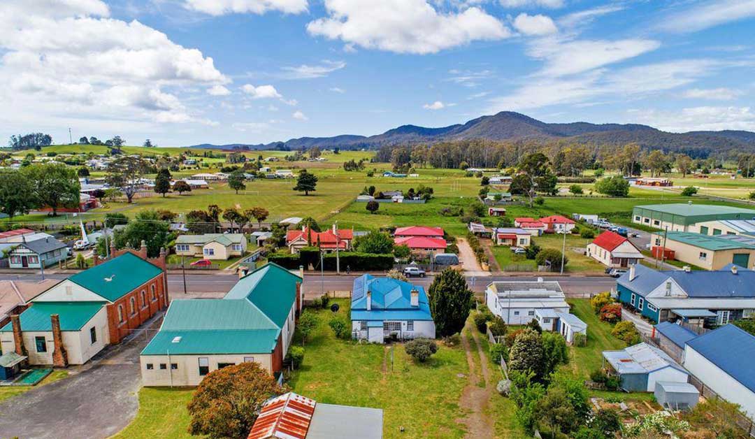
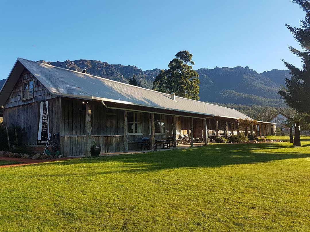
Sheffield, Tasmania

Sheffield has long been the rural hub for the Mount Roland area, and is is well known for its high quality butterfat production via dairy farming, and its lamb and beef production. The area grew slowly, however the commencement of the Mersey-Forth Power Development Scheme and the construction of Lake Barrington in 1963 saw the town grow dramatically.

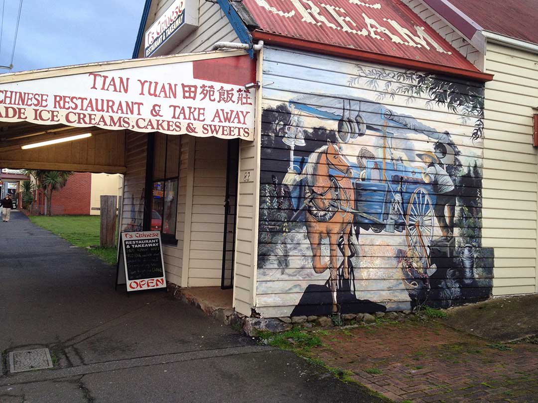
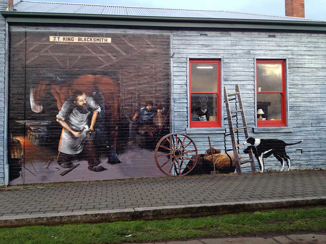
The completion of the power scheme - seven dams and seven power stations - in 1973 saw the town's population decline. Sheffield's revival as the Town of Murals began as a bid by a small group of residents determined to save their town. The first mural commissioned was of Gustav Weindorfer, a passionate mountaineer, naturalist and conservationist. Since then many more murals embellish the building in the town. Sheffield now has more than sixty murals painted on the walls of the town buildings and a further nine murals displayed in Mural Park. These days Sheffield is back on the map, attracting over 200,000 visitors each year, thanks to a large degree to its murals painted on walls throughout the town and buildings along the roadside.
Guide to the Murals of Sheffield
Mural Walk Maps are free of charge and may be obtained from most businesses. The Mural Art Book is also available and can be purchased from most shops or the Visitor Information Centre at 5 Pioneer Cres, Sheffield 9am - 4pm daily.
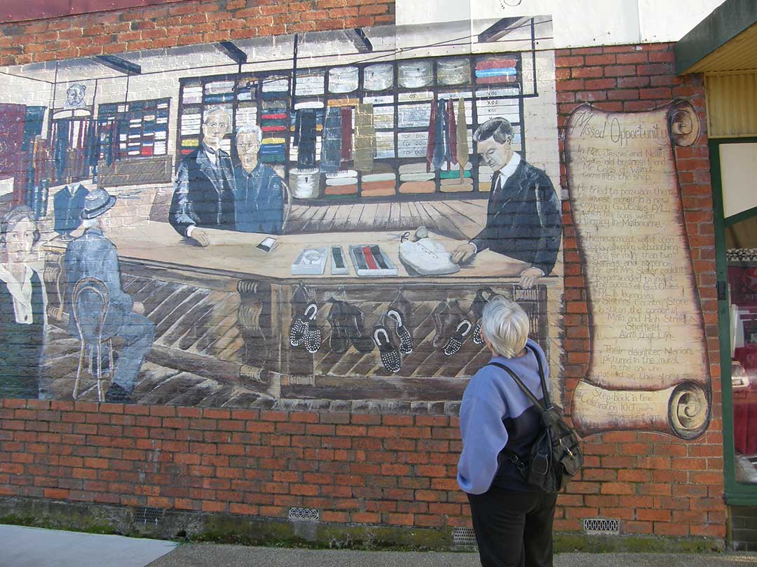
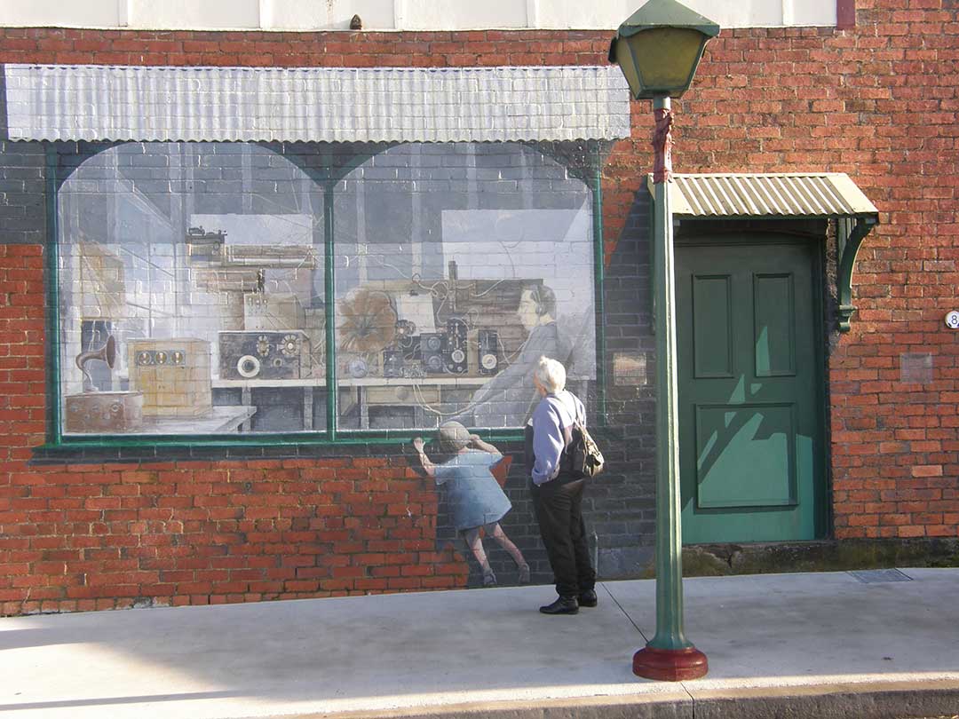
The murals provide genuinely fascinating insights into the local community, its history and culture. A near-perfect example is the mural, The Missed Opportunity (above). Painted by Cheyne Purdue in 1990 and located on High Street it depicts a moment in the town's history when "In 1926 Jesse and Nellie Slater's old business friend, Mr Coles of nearby Wilmot, came into the shop. He tried to persuade them to invest money in a new company, G.J. Coles P/L, which his sons were forming in Melbourne. The new concept was of open display shopping, with nothing selling for more than 2 shillings and sixpence. Mr & Mrs Slater couldn't be persuaded to invest. The success of G.J. Coles P/L is legendary ... Slater's Country Store is still on the corner of Main and High Streets."
The town's name has its origins with James Powlett who came from Sheffield in England. He built the first house in the district which he initially called the Kentish Inn but subsequently changed to the Sheffield Inn. When others moved into the area they adopted Sheffield as the name of the settlement. Kentishbury Post Office opened on 1 November 1862 and was renamed Sheffield in 1882.
There is an alternative explanation that claims the town was named by Edward Curr, the manager of the Van Diemen's Land Company, who was also a native of Sheffield in England. That seems highly unlikely, as Edward Curr had died 9 years before the area was settled, and even then, there is no record of the Van Diemen's Land Company having any agricultural interests in the area.
Website

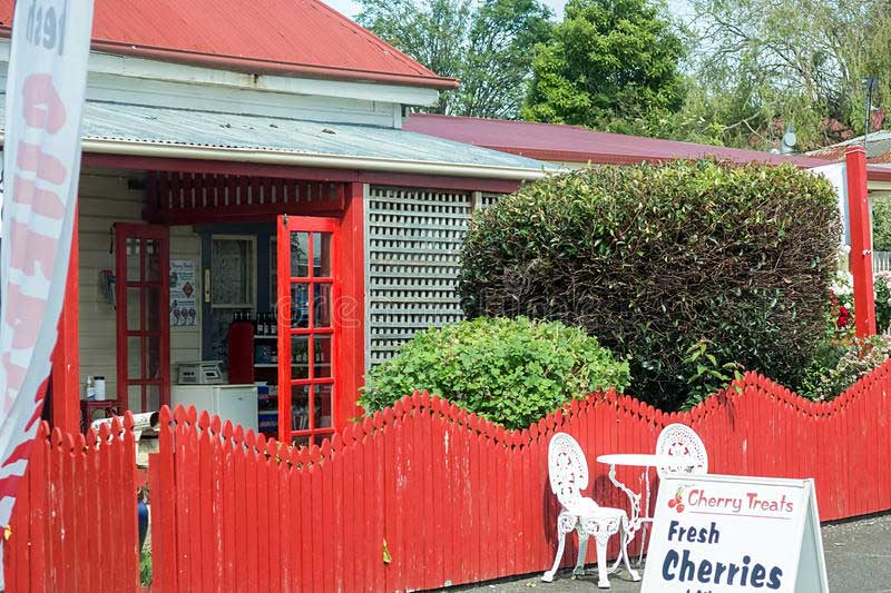
CHERRY TREATS
Offers fresh cherries and cherry related products from preserves through to dried cherries. Cherry Treats operates mid November through to Mid February from premises opposite the Kentish Museum.
92 Main Street, Sheffield, Tas. 7306
Ph: (03) 6491 10615
Website

SHEFFIELD BERRY GARDENS
Grows high quality berries which are sold direct to the public and at Launceston Harvest Market and local Fruit stores.
2764 Sheffield Rd, Sheffield Tas. 7306
Ph: 0427 635 193
Website
MOUNTAIN FRUIT
Berry produce, wines and fruit products available direct from the producer. Fresh berries are available during summer as well as dried fruit bars and frozen raspberries in the off season. A variety of fruit and herb wines are also available.
10 Devils Gate Rd, Barrington TAS 7306
Ph: (03) 6492 3194
Website
TUCKERSHOP @ BARRINGWOOD
Vineyard café selling seasonal, handmade fare. Drop by for snacks, drinks, lunch and outstanding cool climate wines.
Barringwood Estate, 60 Gillams Rd, Lower Barrington 7304
Ph: (03) 6287 6933
Website
THE TRUFFLEDORE
Nestled in the foothills of Tasmania's iconic Cradle Mountain and Mount Roland, The Truffledore offers a little slice of truffle heaven. Country stays available. During the truffle harvest season, June to August, the tasting room is open to the public. Friday and Sunday 10am - 5pm. Hunt & Harvest tours available July to August, bookings required.
15 Reeves Rd, Lower Barrington, Tasmania 7306
Ph: (03) 6492 3353
Website
LAKE BARRINGRON WINERY
One of the oldest and most picturesque vineyards in Tasmania – established in 1984 it produces award winning cold climate sparkling wine. Weekend wine tastings, food and coffee - enjoy a platter and a glass of sparkling at an outdoor table overlooking the vines, the lake and Mt Roland.
1136 West Kentish Road, West Kentish 7306
Ph: (03) 6287 6933
Website
River Don Trading Company building
The River Don Trading Company Store is one of Sheffield's most significant historic buildings. The River Don Trading Company was formed in 1880, when Mr and Mrs John Henry and two associates took over the sawmill, shipping and trading business commenced by Messrs Cummings and Raymond at the River Don, in 1853. John Henry had been part owner of the business since 1872, first as Cummings, Henry and Co, and then John Henry and Co.
The Company was the largest business establishment on the north-west coast, comprising a sawmill, shipping fleet, furniture and upholstery factories, cooperage, butchery, bakery, store and vast acreages of land. After one of the fires which periodically engulfed the premises, this time in 1880, John Henry dropped the less profitable arms and concentrated on his trading stores. The River Don Company became a household name after Henry moved his headquarters to Devonport in 1887, having established branches at Sheffield, Ulverstone, Burnie, Wynyard and Zeehan. Their Sheffield branch building is a large Victorian Italianate store, built in 1883.
Location: 59 Main St, Sheffield.
Kentish Museum building
The Kentish Museum and outbuildings wwere built in 1891. It still has its original stable and shed on the property. The building was incorporated into Sheffield School. Location: 93 Main Street, Sheffield
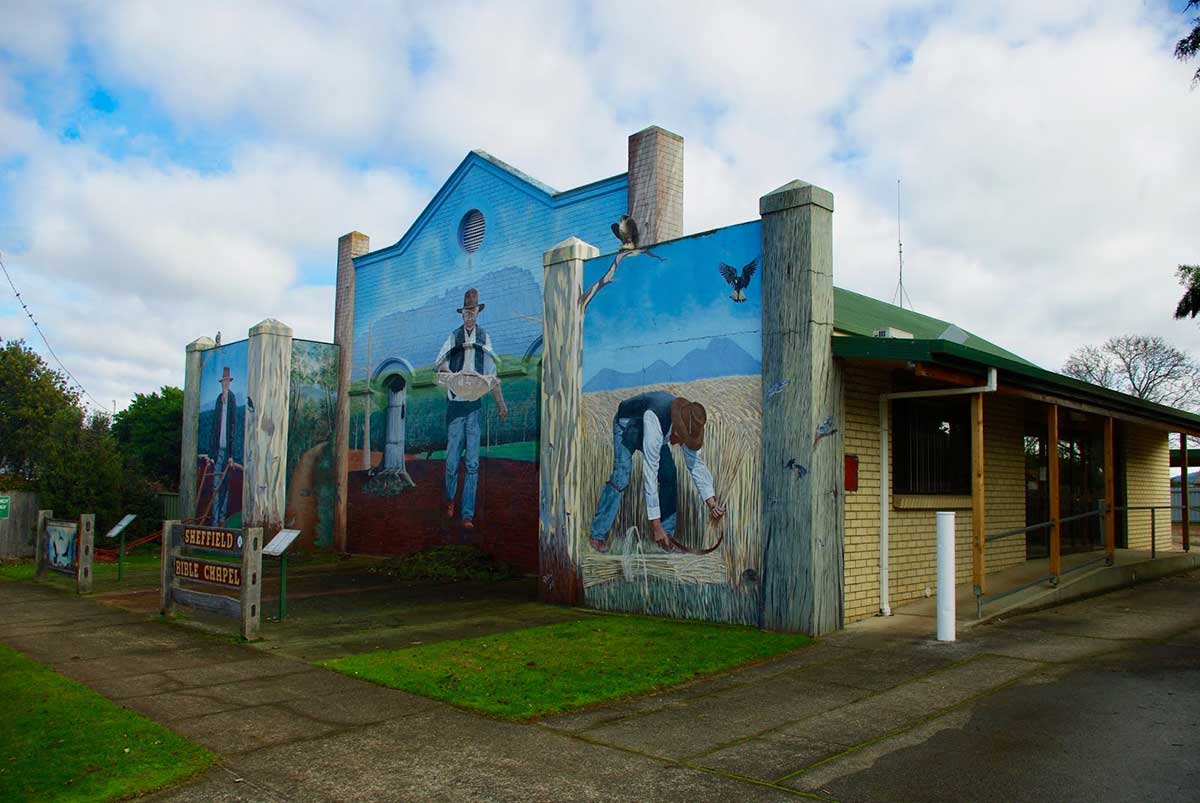
Bible Chapel
Sheffield’s mural-covered Bible Chapel has a long history and it is associated with the early Christian Brethren. The Christian Brethren, also known as the Plymouth Brethren, originated in Great Britain in the 1820s. By the mid 19th century the movement had spread to Australia, with the first revival meetings held in Tasmania from 1869. The first Gospel Hall was established by the Plymouth Brethren in the 1870’s and was situated about 2 kilometres outside of Sheffield on the Kentish Road. It was replaced by a current Gospel Hall in January 1926.
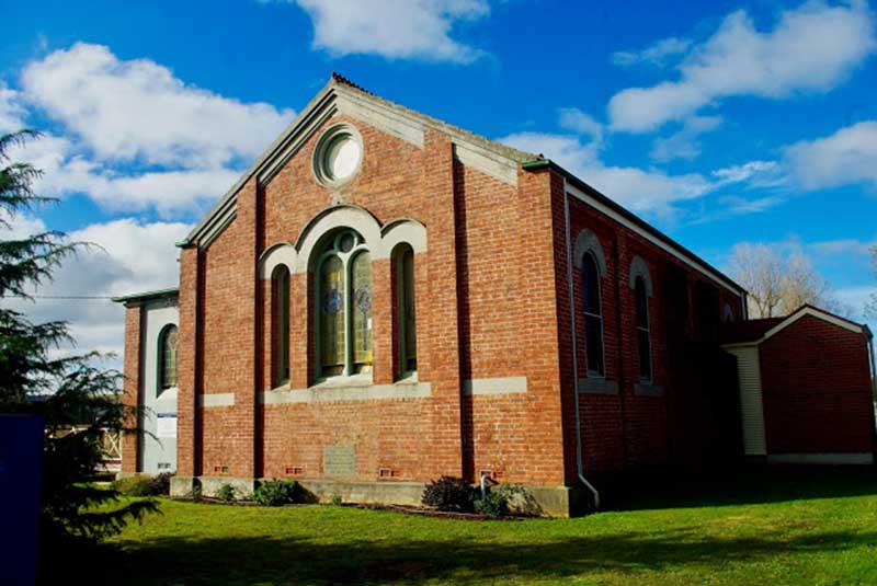
Holy Cross Church
The Catholic Church was the last of the major denominations to become established at Sheffield. At the turn of the 20th century Catholic’s met in Sheffield’s Roland Hall. As early as 1904 there were plans to build a church in the town. The foundation stone-laying ceremony finally took place in November 1921 and in Novembr 1922 the Church of the Holy Cross was opened by Bishop Barry. The striking Romanesque style building still serves Sheffield’s Catholic community.
The inland settlement of Kentish, later named Sheffield, was the last of the North-west's major towns to be established. The original settlement took its name from Nathaniel Lipscomb Kentish, the surveyor who is credited with the discovery of the fertile rolling plains around it that now bear his name.
Surveyor-General Robert Power, who had the responsibility to open roads to every new settlement, hired the 43 year old Nathaniel Lipscomb Kentish when arrived from South Australia in November 1841 looking for a job. Having impressive credentials endorsed by Lieutenant-Governor George Gawler of South Australia, Power appointed him to his Survey Department on the spot. Kentish had been the Surveyor of Roads and Bridges in charge of constructing part of the Great Western Road over the Blue Mountains to Bathurst in New South Wales, with nearly 1000 convicts under his supervision. He'd then moved to South Australia, but before completing his contract, he had moved on to Tasmania.
It soon became clear to Power why Gawler had sent him packing so quickly, but with such a glowing reference - the egotistical surveyor possessed a personality trait that compelled him to constantly promote himself and his own abilities while at the same time denigrating and belittling the efforts of everyone else. His ability to rub others up the wrong way, particularly his superiors, had resulting in him being dismissed time and time again from nearly all his previous employment. One suspects Kentish had no idea why he'd been shown the door so quickly and yet had been given such glowing credentials. Whether or not he knew, he seemed eternally grateful for the favour, reflected in the fact he named one of the first rivers he came across after his beloved former employer.
Kentish surveyed and laid out Burnie in 1843, and ended up living there. In that year, Kentish led a gang of probation convicts to survey a road inland from Burnie. Their journey took them to the plains that would eventually be named in his honour, even though he was not the first European to see them and recognise their agricultural potential. Capt. John Rolland had been that way in 1823 and returned with a glowing report; the Van Diemen’s Land Co.'s surveyors Henry Hellyer and Joseph Fossey had travelled extensively though the North-West's hinterland, though the plains are not mentioned in any of their reports. The convict probation system was abolished before Kentish had time to build the road he had surveyed. He did end up being rewarded after a fashion for the unfinished, arduous task he had taken on, by having the plains named after him, but that almost did not happen. Kentish's boss, Robert Power, insisted they be called the August Plains, as they were discovered by Kentish in the month of August, 1842. Power's successor, James Calder, later changed their name to the Kentish plains, no doubt to appease Kentish.
During their trip, Kentish and his men had come across about eighty unbranded cattle grazing on the plains which are believed to have been strays from the herds of grzier, William Field, of Westbury, who held huge grazing rights to large sections of the Norfolk Plains. Field, who was probably aware of the cattle being there, claimed the cattle and leased around 3,000 acres of the plains for grazing. No further use were made of the plains until district surveyor James M. Dooley of Forth, was sent to survey the area in 1858-59, at which time he set aside two town reserves which would become Railton and Sheffield.
Lots for the newly surveyed town sites went on sale in Launceston on 22nd February 1859. The lots sold quickly, as did 6,000 acres around the town sites that was thrown open for selection. 46 selectors took advantage of the offer. It has been suggested that Edward Curr, Chief Agent of the VDL Co. had named the town of Sheffield after his home town in England. As Curr had left the VDL Co. in 1842 and was now residing at Abbotsford, Victoria, this seems most unlikely, howver one of his employees mat well have influenced the town's naming. James Powlett and his wife, Margaret, were among the first to buy and occupy town lots in the new settlement. They established its first inn, which was soon trading as the Sheffield Inn. They ran the town's first general store and post office from it, with James's brother carrying the mail on horseback between Sheffield and Latrobe. From then onwards, the settlement was known as Sheffield, with the town being officially proclaimed by that name on 20th August 1889.
James George Powlett was born in Sheffield, England in 1809. When he was just a teenager, he was recruited by the VDL Co. to help establish their business interests in North-West Tasmania. On 17 July 1827, 18 year-old James sailed from Hull aboard the SS Caroline, the second of several ships chartered by the VDL Co. to convey their employees, basic supplies and livestock to Circular Head (Stanley). Also sailing on the Caroline was the Ramsdale family, who had also been recruited by the Company. The Ramsdale's 15 year old daughter Margaret and James became close friends. When their 3 year bond with the company expired, they moved away to live together in the Tamar Valley, and were married on 26th July 1831 at St John's Church of England, Launceston.
They established a farming property at Red Hills between Deloraine and Chudleigh called Parkland Grove, and became weathy and highly-respected members of the comunity. When the Kentish Plains were opened up for agricultural development, they saw its potential and, along with Margaret's brother, John, bought up numerous town lots including a number at both ends of the township. The name Sheffield was suggested by Surveyor James Dooley, when he laid out the town. At that time, he would have been aware that the Powletts had already selected land around the townsite, and intended to sell up Parkland Grove and Sherwood Inn at Latrobe, which they also owned, take up residence in the new township and establish an inn. It is likely that George Powlett might have approached Dooley, suggesting he name the town Sheffield, as the inn he intended to build there would be the Sheffield Inn.
The Powletts, John Ramsdale along with other relatives and business associates ended up buying numerous lots at either end of the town. At the western end of Sheffield, James Bennett, who had taken over Red Hills, bought all the land west of High Street, which at that time was the town's western boundary. He also purchased many surrounding blocks of land. Unlike the Powletts who were genuine settlers, Bennett bought his land as a speculator and never lived there. By April 1861, the Powlett family moved from Sherwood and Red Hills to their property on Kermode Street, Sheffield, the eastern boundary of the town.
The completion of the power scheme - seven dams and seven power stations - in 1973 saw the town's population decline. Sheffield's revival as the Town of Murals began as a bid by a small group of residents determined to save their town. The first mural commissioned was of Gustav Weindorfer, a passionate mountaineer, naturalist and conservationist. Since then many more murals embellish the building in the town. Sheffield now has more than sixty murals painted on the walls of the town buildings and a further nine murals displayed in Mural Park. These days Sheffield is back on the map, attracting over 200,000 visitors each year, thanks to a large degree to its murals painted on walls throughout the town and buildings along the roadside.
Guide to the Murals of Sheffield
Mural Walk Maps are free of charge and may be obtained from most businesses. The Mural Art Book is also available and can be purchased from most shops or the Visitor Information Centre at 5 Pioneer Cres, Sheffield 9am - 4pm daily.
The murals provide genuinely fascinating insights into the local community, its history and culture. A near-perfect example is the mural, The Missed Opportunity (above). Painted by Cheyne Purdue in 1990 and located on High Street it depicts a moment in the town's history when "In 1926 Jesse and Nellie Slater's old business friend, Mr Coles of nearby Wilmot, came into the shop. He tried to persuade them to invest money in a new company, G.J. Coles P/L, which his sons were forming in Melbourne. The new concept was of open display shopping, with nothing selling for more than 2 shillings and sixpence. Mr & Mrs Slater couldn't be persuaded to invest. The success of G.J. Coles P/L is legendary ... Slater's Country Store is still on the corner of Main and High Streets."
The town's name has its origins with James Powlett who came from Sheffield in England. He built the first house in the district which he initially called the Kentish Inn but subsequently changed to the Sheffield Inn. When others moved into the area they adopted Sheffield as the name of the settlement. Kentishbury Post Office opened on 1 November 1862 and was renamed Sheffield in 1882.
There is an alternative explanation that claims the town was named by Edward Curr, the manager of the Van Diemen's Land Company, who was also a native of Sheffield in England. That seems highly unlikely, as Edward Curr had died 9 years before the area was settled, and even then, there is no record of the Van Diemen's Land Company having any agricultural interests in the area.
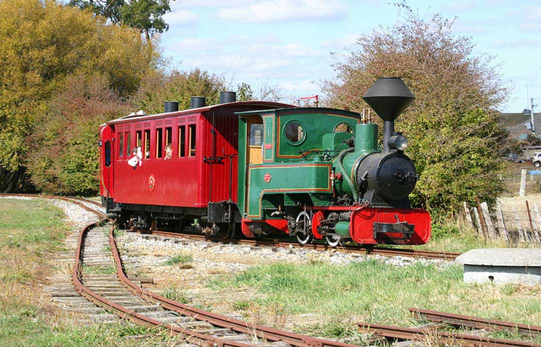
Redwater Creek Heritage Railway
Redwater Creek Steam and Heritage Society currently has over 1km of track. Its train is hauled by a 1906 Krauss 610mm gauge steam loco and consists of Tasmanian heritage coaches. Steam train rides operate on the first full weekend of every month from the original Sheffield railway station. Trains run every half hour from 11am until 4pm on Saturday and Sunday.Website
CHERRY TREATS
Offers fresh cherries and cherry related products from preserves through to dried cherries. Cherry Treats operates mid November through to Mid February from premises opposite the Kentish Museum.
92 Main Street, Sheffield, Tas. 7306
Ph: (03) 6491 10615
Website
SHEFFIELD BERRY GARDENS
Grows high quality berries which are sold direct to the public and at Launceston Harvest Market and local Fruit stores.
2764 Sheffield Rd, Sheffield Tas. 7306
Ph: 0427 635 193
Website
Barrington
MOUNTAIN FRUIT
Berry produce, wines and fruit products available direct from the producer. Fresh berries are available during summer as well as dried fruit bars and frozen raspberries in the off season. A variety of fruit and herb wines are also available.
10 Devils Gate Rd, Barrington TAS 7306
Ph: (03) 6492 3194
Website
Lower Barrington
TUCKERSHOP @ BARRINGWOOD
Vineyard café selling seasonal, handmade fare. Drop by for snacks, drinks, lunch and outstanding cool climate wines.
Barringwood Estate, 60 Gillams Rd, Lower Barrington 7304
Ph: (03) 6287 6933
Website
THE TRUFFLEDORE
Nestled in the foothills of Tasmania's iconic Cradle Mountain and Mount Roland, The Truffledore offers a little slice of truffle heaven. Country stays available. During the truffle harvest season, June to August, the tasting room is open to the public. Friday and Sunday 10am - 5pm. Hunt & Harvest tours available July to August, bookings required.
15 Reeves Rd, Lower Barrington, Tasmania 7306
Ph: (03) 6492 3353
Website
West Kentish
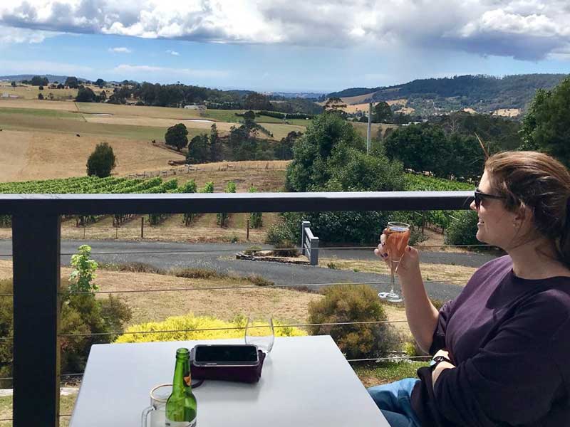
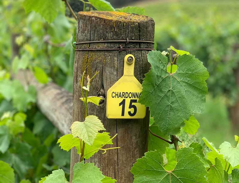
LAKE BARRINGRON WINERY
One of the oldest and most picturesque vineyards in Tasmania – established in 1984 it produces award winning cold climate sparkling wine. Weekend wine tastings, food and coffee - enjoy a platter and a glass of sparkling at an outdoor table overlooking the vines, the lake and Mt Roland.
1136 West Kentish Road, West Kentish 7306
Ph: (03) 6287 6933
Website

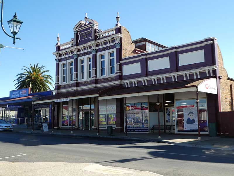
River Don Trading Company building
The River Don Trading Company Store is one of Sheffield's most significant historic buildings. The River Don Trading Company was formed in 1880, when Mr and Mrs John Henry and two associates took over the sawmill, shipping and trading business commenced by Messrs Cummings and Raymond at the River Don, in 1853. John Henry had been part owner of the business since 1872, first as Cummings, Henry and Co, and then John Henry and Co.
The Company was the largest business establishment on the north-west coast, comprising a sawmill, shipping fleet, furniture and upholstery factories, cooperage, butchery, bakery, store and vast acreages of land. After one of the fires which periodically engulfed the premises, this time in 1880, John Henry dropped the less profitable arms and concentrated on his trading stores. The River Don Company became a household name after Henry moved his headquarters to Devonport in 1887, having established branches at Sheffield, Ulverstone, Burnie, Wynyard and Zeehan. Their Sheffield branch building is a large Victorian Italianate store, built in 1883.
Location: 59 Main St, Sheffield.
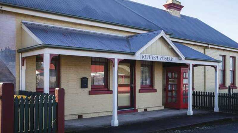
Kentish Museum building
The Kentish Museum and outbuildings wwere built in 1891. It still has its original stable and shed on the property. The building was incorporated into Sheffield School. Location: 93 Main Street, Sheffield
Bible Chapel
Sheffield’s mural-covered Bible Chapel has a long history and it is associated with the early Christian Brethren. The Christian Brethren, also known as the Plymouth Brethren, originated in Great Britain in the 1820s. By the mid 19th century the movement had spread to Australia, with the first revival meetings held in Tasmania from 1869. The first Gospel Hall was established by the Plymouth Brethren in the 1870’s and was situated about 2 kilometres outside of Sheffield on the Kentish Road. It was replaced by a current Gospel Hall in January 1926.
Holy Cross Church
The Catholic Church was the last of the major denominations to become established at Sheffield. At the turn of the 20th century Catholic’s met in Sheffield’s Roland Hall. As early as 1904 there were plans to build a church in the town. The foundation stone-laying ceremony finally took place in November 1921 and in Novembr 1922 the Church of the Holy Cross was opened by Bishop Barry. The striking Romanesque style building still serves Sheffield’s Catholic community.

The inland settlement of Kentish, later named Sheffield, was the last of the North-west's major towns to be established. The original settlement took its name from Nathaniel Lipscomb Kentish, the surveyor who is credited with the discovery of the fertile rolling plains around it that now bear his name.
Surveyor-General Robert Power, who had the responsibility to open roads to every new settlement, hired the 43 year old Nathaniel Lipscomb Kentish when arrived from South Australia in November 1841 looking for a job. Having impressive credentials endorsed by Lieutenant-Governor George Gawler of South Australia, Power appointed him to his Survey Department on the spot. Kentish had been the Surveyor of Roads and Bridges in charge of constructing part of the Great Western Road over the Blue Mountains to Bathurst in New South Wales, with nearly 1000 convicts under his supervision. He'd then moved to South Australia, but before completing his contract, he had moved on to Tasmania.
It soon became clear to Power why Gawler had sent him packing so quickly, but with such a glowing reference - the egotistical surveyor possessed a personality trait that compelled him to constantly promote himself and his own abilities while at the same time denigrating and belittling the efforts of everyone else. His ability to rub others up the wrong way, particularly his superiors, had resulting in him being dismissed time and time again from nearly all his previous employment. One suspects Kentish had no idea why he'd been shown the door so quickly and yet had been given such glowing credentials. Whether or not he knew, he seemed eternally grateful for the favour, reflected in the fact he named one of the first rivers he came across after his beloved former employer.
Kentish surveyed and laid out Burnie in 1843, and ended up living there. In that year, Kentish led a gang of probation convicts to survey a road inland from Burnie. Their journey took them to the plains that would eventually be named in his honour, even though he was not the first European to see them and recognise their agricultural potential. Capt. John Rolland had been that way in 1823 and returned with a glowing report; the Van Diemen’s Land Co.'s surveyors Henry Hellyer and Joseph Fossey had travelled extensively though the North-West's hinterland, though the plains are not mentioned in any of their reports. The convict probation system was abolished before Kentish had time to build the road he had surveyed. He did end up being rewarded after a fashion for the unfinished, arduous task he had taken on, by having the plains named after him, but that almost did not happen. Kentish's boss, Robert Power, insisted they be called the August Plains, as they were discovered by Kentish in the month of August, 1842. Power's successor, James Calder, later changed their name to the Kentish plains, no doubt to appease Kentish.
During their trip, Kentish and his men had come across about eighty unbranded cattle grazing on the plains which are believed to have been strays from the herds of grzier, William Field, of Westbury, who held huge grazing rights to large sections of the Norfolk Plains. Field, who was probably aware of the cattle being there, claimed the cattle and leased around 3,000 acres of the plains for grazing. No further use were made of the plains until district surveyor James M. Dooley of Forth, was sent to survey the area in 1858-59, at which time he set aside two town reserves which would become Railton and Sheffield.
Lots for the newly surveyed town sites went on sale in Launceston on 22nd February 1859. The lots sold quickly, as did 6,000 acres around the town sites that was thrown open for selection. 46 selectors took advantage of the offer. It has been suggested that Edward Curr, Chief Agent of the VDL Co. had named the town of Sheffield after his home town in England. As Curr had left the VDL Co. in 1842 and was now residing at Abbotsford, Victoria, this seems most unlikely, howver one of his employees mat well have influenced the town's naming. James Powlett and his wife, Margaret, were among the first to buy and occupy town lots in the new settlement. They established its first inn, which was soon trading as the Sheffield Inn. They ran the town's first general store and post office from it, with James's brother carrying the mail on horseback between Sheffield and Latrobe. From then onwards, the settlement was known as Sheffield, with the town being officially proclaimed by that name on 20th August 1889.
James George Powlett was born in Sheffield, England in 1809. When he was just a teenager, he was recruited by the VDL Co. to help establish their business interests in North-West Tasmania. On 17 July 1827, 18 year-old James sailed from Hull aboard the SS Caroline, the second of several ships chartered by the VDL Co. to convey their employees, basic supplies and livestock to Circular Head (Stanley). Also sailing on the Caroline was the Ramsdale family, who had also been recruited by the Company. The Ramsdale's 15 year old daughter Margaret and James became close friends. When their 3 year bond with the company expired, they moved away to live together in the Tamar Valley, and were married on 26th July 1831 at St John's Church of England, Launceston.
They established a farming property at Red Hills between Deloraine and Chudleigh called Parkland Grove, and became weathy and highly-respected members of the comunity. When the Kentish Plains were opened up for agricultural development, they saw its potential and, along with Margaret's brother, John, bought up numerous town lots including a number at both ends of the township. The name Sheffield was suggested by Surveyor James Dooley, when he laid out the town. At that time, he would have been aware that the Powletts had already selected land around the townsite, and intended to sell up Parkland Grove and Sherwood Inn at Latrobe, which they also owned, take up residence in the new township and establish an inn. It is likely that George Powlett might have approached Dooley, suggesting he name the town Sheffield, as the inn he intended to build there would be the Sheffield Inn.
The Powletts, John Ramsdale along with other relatives and business associates ended up buying numerous lots at either end of the town. At the western end of Sheffield, James Bennett, who had taken over Red Hills, bought all the land west of High Street, which at that time was the town's western boundary. He also purchased many surrounding blocks of land. Unlike the Powletts who were genuine settlers, Bennett bought his land as a speculator and never lived there. By April 1861, the Powlett family moved from Sherwood and Red Hills to their property on Kermode Street, Sheffield, the eastern boundary of the town.
Beyond Sheffield
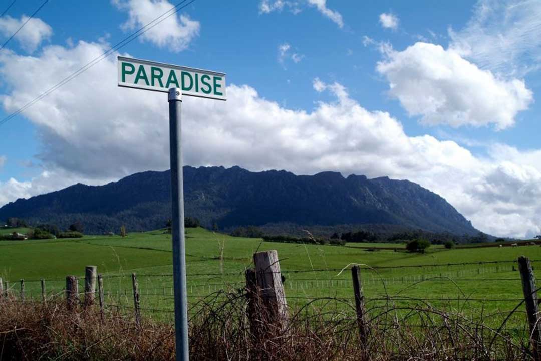
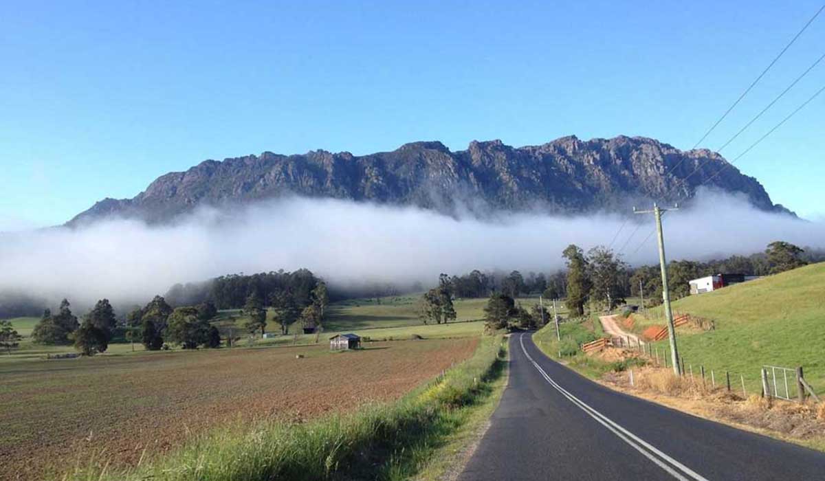
Names like Promised Land, Paradise and No Where Else were used to encapsulate the beauty of the region. Visitors today believe this still rings true! Rich agricultural fields, rolling green hills and natural vistas are all around you when journeying to Sheffield, Cradle Mountain, Wilmot and Railton. As you drive, you experience the change of environments from low lying grassy plains to the foothills and grandeur of Mt Roland, the most prominent landscape feature visitors see en route to Sheffield.
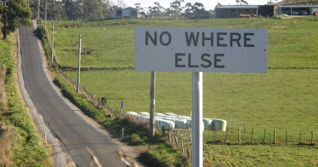
When driving from Sheffield to Wilmot, you will go through the most quaintly named place in Australia - No Where Else. What is there at No Where Else? Not much really, there are no shops, no pub, no general store or toilets, just a few farm houses and an interesting sign to have your photo taken under! Nowhere Else came into being because the original road from Barrington ended at the entrance to a farm. When drivers asked the farmer what was further on he told them 'No where Else'.
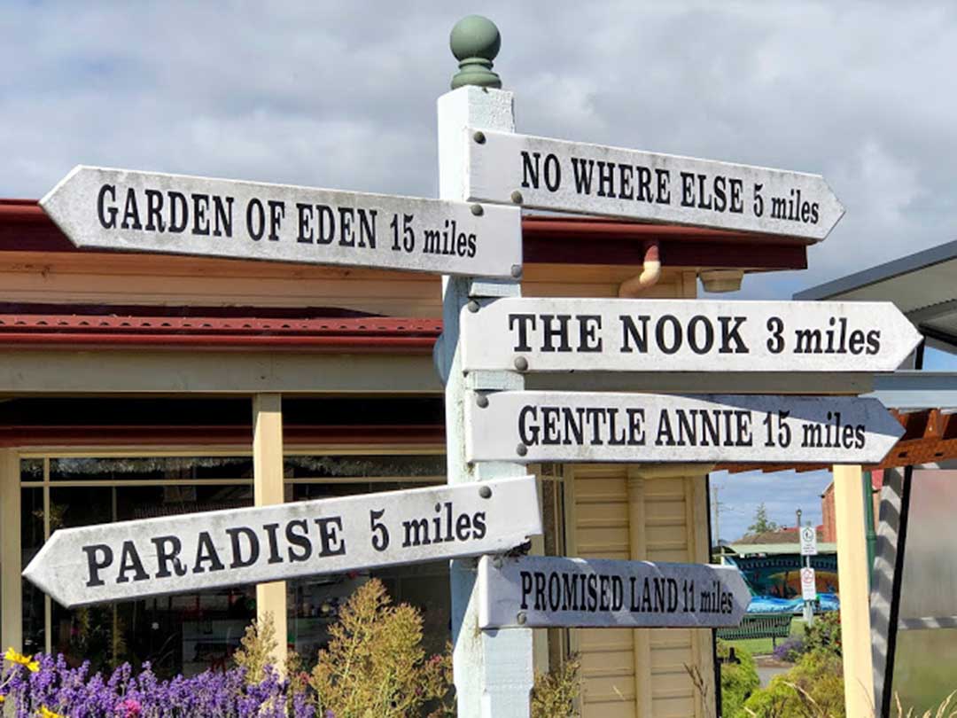
If No Where Else is not quirky enough for you, then there are plenty of other oddly-named localities in the area to explore and find a unique street sign to pose and take a selfie under. For example, there's Paradise, named by its first white settlers who were devout Calvinists. The original name was Reuben Austen's Paradise, after one of the settlers who remarked upon seeing the sun glistening on the picturesque mountain vista, "This is Paradise."
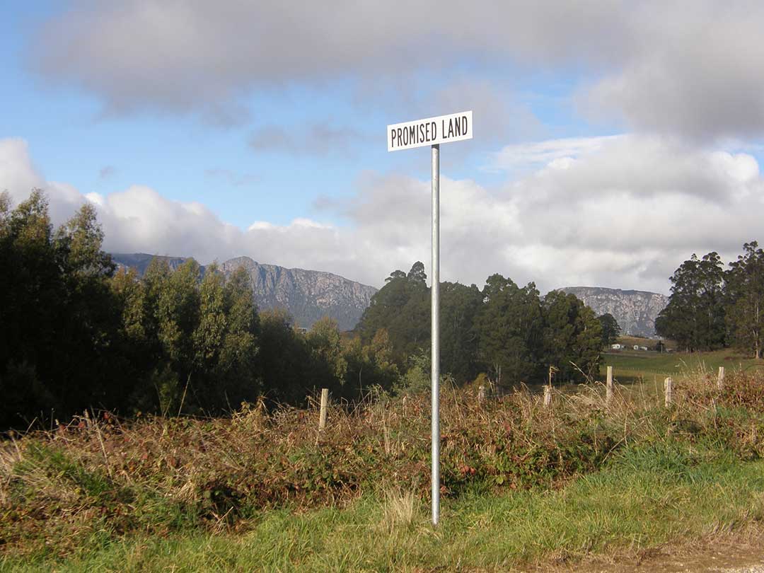
Then there's "Primised Land". Anyone who hasn't been here could be forgiven for thinking the locality's name is nothing more than a gimmick generated by a hot-shot real estate agent to capture the imagination of potential buyers. But when you drive through the area, it's not hard to see why the first white settlers here believed that had reached the promised land. This very picturesque rural locality is a rich farming area bounded by Lake Barrington on one side and the dramatic peaks of the Great Western Tiers on the other.
More
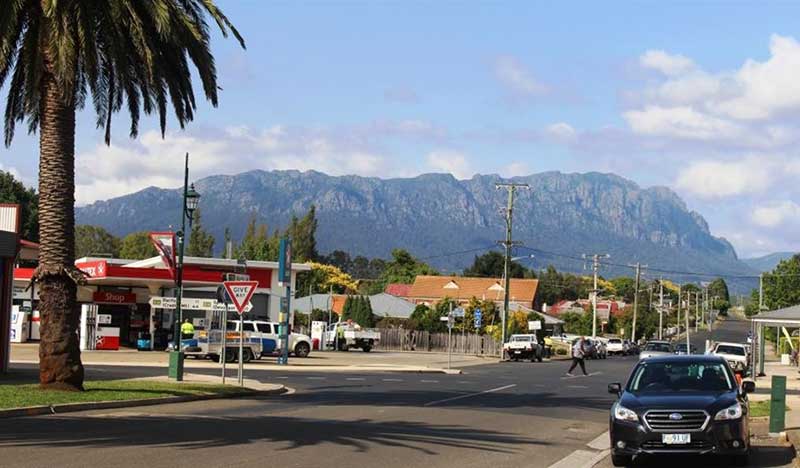
Mount Roland
Mount Roland stands at 1234 meters above sea level on the northern edge of the Great Western Tiers region of Tasmania. It provides an imposing backdrop to the Kentish Municipality and for the town of Sheffield. Like many of Tasmania's mountains, at first sight it would appear to be a difficult climb. From most angles it presents the onlooker with the steep bastions of seemingly impregnable cliffs. These ramparts form the containment walls of a huge dolerite plateau of which the summit tor is but a small part.A number of well marked bushwalks provide a day's exercise. There are walking tracks from Claude Road and Gowrie Park to the summit. The walk includes the plains and plateau leading to the peak. There are two tracks to the summit, which provide 360-degree views to Bass Strait, Cradle Mountain and Barn Bluff. Mount Roland stands at 1234 metres above sea level.
More
Mersey Forth Hydro Scheme
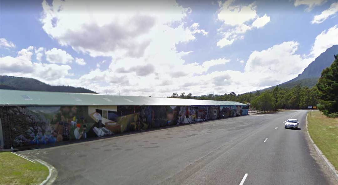
Various aspects of the Mersey Forth Power Development are depicted in a mural on Claude Road, Gowrie Park (above), which is believed to be the longest in the Southern Hemisphere. The mural is painted on the workshop and stores building of the Hydro Electric Commission depot. It tells the story of exploration, negotiating scrub on horseback, surveyors, construction, engineering, automated technology, the township of Gowrie Park through to the modern day water skiers on Lake Barrington.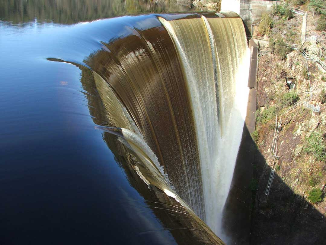
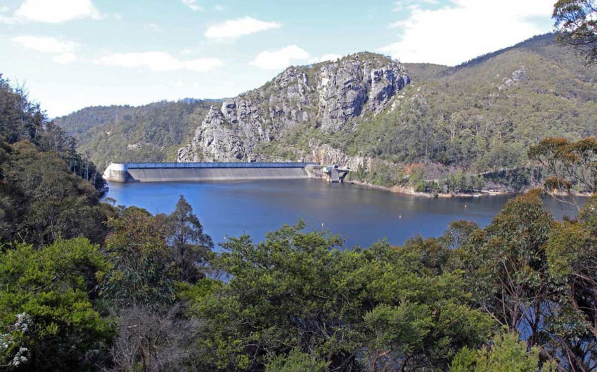
The Devils Gate Dam has an overhanging crest that allows flood water to freefall to the river bed, with up to 2000 tonnes of water falling per second during an extreme flood. It is one of the thinnest concrete arch dams in the world. It was completed by the Hydro-Electric Commission in 1969 and is 84 metres high. The narrowness of the gorge and the computer-aided design of its double-curvature shape enabled engineers to minimise the volume of concrete and hence the cost of the dam. Flood waters falling freely from the crest strike concrete slabs carefully positioned on the abutments to prevent undermining of the dam by erosion.
A walk to Lake Cethana starts at the junction just before the turn into Lemonthyme Lodge. The walk takes about two hours and allows visitors to observe the varieties of vegetation of the area. After crossing two areas of cleared land the track crosses a fern gully, beyond which there is more forest until the track terminates in the backwater of the lake. This walk is graded as hard because the return trip is a long haul uphill.
More
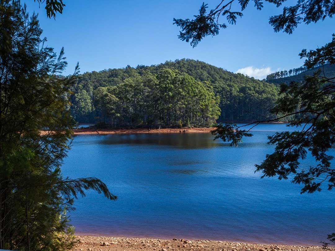
Lake Barrington
Lake Barrington is known as an international standard rowing venue and the site of the 1990 World Rowing Championships. It was created in 1969 by building the Devils Gate Dam on the Forth River. The lake is a popular water ski location with access via West Kentish and Wilmot. There are two water ski clubs based at Lake Barrington: Kentish Aquatic Club and Horsehead Water Ski Club. The lake is also used for canoeing and trout fishing. There is an adventure playground and a two-hour rainforest walk. Facilities for visitors include picnic sites, boat ramps and toilets.Lake Barrington is but one piece in the Mersey Forth Power Development which covers an area of 2,070 square km and uses water originating on the Great western Tiers, augmented by the Fisher, Mersy, Wilmot and Forth rivers. This water pases through seven power stations, seven large dams, three major tunnels and various penstocks, canals and flumes and several artificial lakes before it reaches Bass Strait. The construction of the Development is both an important and complex engineering masterpiece.
More
Gowrie Park
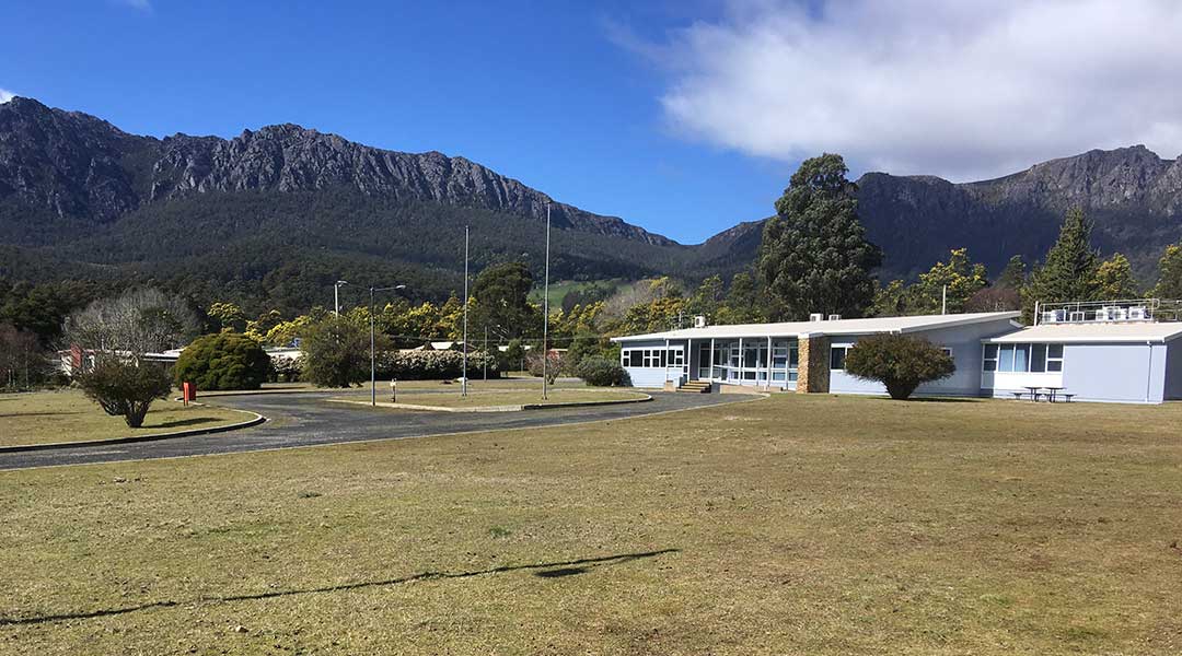
15.3 km south-west of Sheffield via Claude RoadThe small town of Gowrie Park is located 16 kilometres south of Sheffield. It is a starting point for walkers climbing Mount Roland. The town has a history as a Hydro construction village. Investigation for the power scheme began in 1952 and construction commenced in 1963. The scheme consists of seven dams and power stations which harness the waters of the Fisher, Mersey, Wilmot and Forth Rivers. The Cethana Dam is the second largest of its type in Tasmania and the Devil’s Gate Dam is a high concrete arch which forms Lake Barrington.
During the construction of the Mersey Forth Power Scheme, Gowrie Park was home for almost 2,000 people. The Hydro Electric Commission created an instant town complete with butcher shop, police station, school, church, cinema, medical centre and general store. The Gowrie Park School catered for the children of the 250 families with some class sizes as high as fifty seven. Many different languages were spoken due to the diversity of countries from which the work force was drawn.
However, with the completion of the scheme, the town disappeared almost as quickly as it had risen. Although the HEC still operates a maintenance depot from Gowrie Park, little remains of the township today apart from daffodils which come up in spring to flag the location of former homes. Much of the township site is now operated as Wilderness accommodation centre, featuring murals, pioneer settlement and licensed restaurant.
Mersey Forth Power Development

Wilmot
39.6 km from Sheffield via Sheffield Road and Lower BarringtonWilmot is one of those kind of places where the journey getting there is as much fun as being there. The big drawcard for me was always the original Coles family store, from which came "GJ", the son George who decided to move to the mainland and Melbourne, where he figured he had more chance to make a million that if he stayed in the backblocks of North West Tasmania. It was a move that paid off handsomely - his venture grew into the gigantic Coles retail empire we see today. Sadly, the original Coles store at Wilmot burnt down some years ago.
More
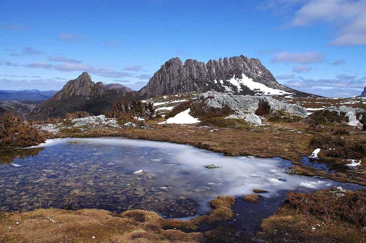
Cradle Mountain
53.9 km from Sheffield via Cradle Mountain RoadCradle Mountain is approximately one hour's drive south-west of the township of Sheffield. Australia's most recognisable mountain, Cradle Mountain forms the northern end of the wild Cradle Mtn.-Lake St Clair National Park, itself a part of the Tasmanian Wilderness World Heritage Area. The familiar jagged contours of Cradle Mountain epitomise the feel of a wild landscape, while abundant wildlife, icy streams, alpine heathlands, colourful deciduous beech and ancient pines reflected in still glacial lakes entice many visitors to stay and explore.
More
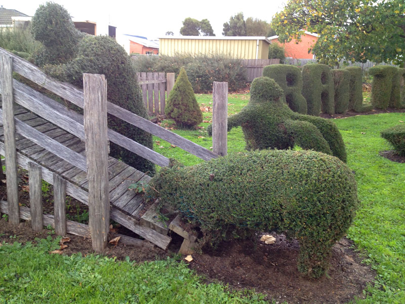
Railton
14.9 km north-east of Sheffield via Railton RoadThe main attraction in this rural inland town is topiary, which is the art of shaping bushes and trees by careful pruning to resemble familiar objects such as animals. The town is 12 km from Sheffield.
More
Kimberley Warm Springs
16.8 km east of Sheffield via Railton Road and Bridal Track RoadKimberley Warm Springs are a geothermal feature and semi-developed visitor site located in the nearby town of Kimberley. The micro climate created by the warm springs creates a unique habitat.
Kimberley was once a thriving village with a school, railway station, shops and two churches, and is now a collection of houses with one church (St Michael and All Angels Anglican Church) remaining. The White Rock Vineyard is close to the township. There is also an olive grove. The area is known for its dairy farms, beef breeding and fattening, prime lamb production, some cropping and irrigation. The Mersey River forms part of the southern boundary, flows through from south to north, and then forms part of the northern boundary.
Deloraine
38.1 km south-east of Sheffield via Railton RoadDeloraine is a delightful town in the valley of the Meander River, with many heritage buildings, both in its main street and surrounding areas. The town's resident population of around 2,000 swells by 30,000 when Australia's biggest working craft fair comes to town every November. Held over four days, more than 200 exhibitors show everything from kites to candle wicks, kaleidoscopes to fine silkscreen paintings, woodcarvings, lead lights and hand-blown glassware.
More
A PocketOz Travel and Information Guide
Design and concept © Stephen Yarrow | Email | W3Layouts | Test